Baja California
peninsula, Mexico
English Lower California
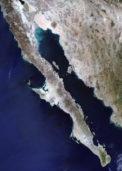 peninsula, northwestern Mexico, bounded to the north by the United States, to the east by the Gulf of California, and to the south and west by the Pacific Ocean. The peninsula is approximately 760 miles (1,220 km) long and 25 to 150 miles (40 to 240 km) wide, with a total area of 55,366 square miles (143,396 square km). Politically, it is divided into the Mexican states of Baja California and Baja California Sur.The basic geologic feature is a fault block rising precipitously on the gulf side and dropping gently into the Pacific, crowned by a chain of rugged peaks trending in a northwest-southeast direction. The granitic Juárez and San Pedro Mártir mountains, the latter rising to 10,154 feet (3,095 metres) above sea level, form the divide in the north, with lower parallel ranges much interrupted by erosion along both coasts. The centre of the peninsula is dominated by volcanoes and vast lava flows extending westward in a subpeninsula. Volcanoes include Las Tres Vírgenes (6,548 feet 【1,996 metres】), last reported active in 1746. In the vicinity of the city of La Paz, the mountains disappear in a low, narrow isthmus, after which they reemerge in a final, lofty (7,100-foot 【2,150-metre】) granite range. The most extensive plains are along the Pacific shore in the south, from near La Paz to Ojo de Liebre (Scammon's) Lagoon. At the head of the Gulf of California is a delta formed by the alluvium of the Colorado River.
Baja California has 2,038 miles (3,280 km) of coastline, with many islands on both sides. There are sheltered deepwater harbours on the western coast as well as on the gulf. With the exception of the Colorado River, which flows intermittently along the extreme northeast part of the peninsula, surface water is confined to a few streamlets in the northwest and extreme south and to rare springs forming oases elsewhere.
Three zones of climate determine the region's plant and animal life. The northwestern corner of the peninsula receives winter cyclonic cold fronts bringing rain and fog from the north. Precipitation in this part ranges from 5 to 11 inches (130 to 280 mm) annually, and the vegetation and fauna are similar to those of southern California in the United States. Southward from El Rosario and east of the Juárez–San Pedro Mártir mountains is an excessively arid zone extending through the waist of the peninsula to La Paz. Parts of this great central desert are quite barren, but most of it is covered with forests of plants adapted to arid conditions, notably the giant cactus, or cardon (Pachycereus), and two other species, the boojum tree (Idria columnaris) and the elephant tree (Bursera microphylla). The region south of La Paz receives late summer tropical rains averaging 5 inches (130 mm) annually on the coast and 25 inches (635 mm) or more in the higher mountains, with desert shrub in the lowlands and semideciduous forests in the more humid mountains. Lowland temperatures in the peninsula range from below freezing (even in the south) to higher than 100 °F (38 °C). The gulf coast is hot and humid in summer, while the Pacific side is much cooler.
Humans first moved into Baja California from the north perhaps 9,000 or 10,000 years ago, when the climate was more humid and huge Pleistocene mammals roamed the area. When the Spaniards landed in 1533, they found what were among the most primitive cultures in the Americas. An estimated 60,000 to 70,000 Indians lived at that time in small groups, each exploiting a definite territory for hunting, fishing, and gathering wild plants. Attempts to colonize the peninsula were fruitless until Jesuit missionaries established the first of a number of permanent settlements at Loreto in 1697. These missionaries congregated, clothed, and catechized the Indians and taught them agriculture and livestock husbandry, but the Indians were practically exterminated in a series of epidemics unwittingly introduced by the Spaniards. In 1768 the Jesuits were replaced by Franciscans, who in turn left the peninsular missions to the Dominican order five years later. By this time few Indians remained in the southern part of the peninsula, and the Dominicans concentrated on founding new missions in the north to convert the still undecimated tribes there. Independence from Spain was recognized in Baja California in 1822. The missions were gradually abandoned, and the vanished Indians were replaced by a sparse population of mestizo farmers and cattlemen. After the Mexican War (1846–48), the Treaty of Guadalupe Hidalgo (Guadalupe Hidalgo, Treaty of) gave California proper to the United States and assigned Lower California—i.e., the Baja peninsula—to Mexico.
Highway, harbour facility, and airfield improvements and construction began in the 1960s and have continued. In 1973 a 1,061-mile (1,708-km) highway, connecting Tijuana and Cape San Lucas, was completed. Subsequently Baja California's isolation was alleviated, and its agriculture, mining, tourism, and other industries, especially in the northern half of the peninsula, have expanded.
state, Mexico
also called Baja California Norte
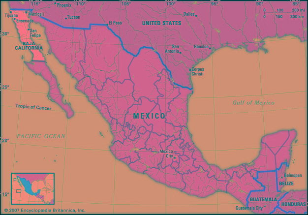 estado (state), northwestern Mexico, bounded to the north by the United States ( California and Arizona) (Arizona), to the east by the state of Sonora and the Gulf of California (California, Gulf of) (Sea of Cortez), to the west by the Pacific Ocean, and to the south by the state of Baja California Sur. Its capital city, Mexicali, lies on the U.S.-Mexico border, opposite Calexico, Calif.
The state occupies the northern half of the Baja California peninsula and consists of rugged granitic mountains, the Sierra de Juárez and the Sierra San Pedro Mártir. Much of the state is occupied by a westward extension of the Sonoran Desert. Coastal plains are narrow except in the extreme northeast, where the Colorado River has formed a delta; however, the Colorado is now used so heavily upstream (mainly to supply crop irrigation and the population centres north of the border) that its remaining waters typically evaporate or seep into the desert before reaching the gulf.
Although the state of Baja California has long been inhabited, settlement of the area has been sparse. The peninsula remained in Spanish possession until 1822, the year after Mexico gained its independence. In 1887 the peninsula was divided into two federal districts; the first capital of northern Baja California was at Ensenada. The district was redesignated as a federal territory in 1931 and became a state in 1952. The name was changed to Baja California Norte in 1974 to distinguish it from the newly created state of Baja California Sur, but by 1979 it was again officially called Baja California.
State government is headed by a governor elected to a single six-year term. Members of the unicameral House of Deputies serve terms of three years. The legislature can levy taxes, but in reality the state depends on the federal government for most of its revenue. Baja California is divided into five local governmental units called municipios (municipalities), each of which is headquartered in its largest town.
Baja California's proximity to U.S. markets and the development of maquiladoras (export-oriented assembly plants) have spurred rapid growth. Implementation of the North American Free Trade Agreement in 1994 intensified the state's economic ties with the United States. Tijuana, ideally situated just south of San Diego, Calif., is the leading maquiladora centre, followed by Mexicali and Tecate. Major manufactures include electronics, textiles, plastics, metal products, automobile components, paper, beverages, and processed foods. The state's agriculture and industry attract large numbers of immigrants from other Mexican states and Central America. Baja California has one of Mexico's largest fishing industries, which is centred on Ensenada, one of the country's busiest ports.
Tourism is also important, notably because of the large number of short-term visitors from California. The beaches at Rosarito are popular with tourists, and Tecate has a famous brewery. Islands and coastal areas in the Gulf of California that belong to Baja California are part of a larger gulfwide UNESCO World Heritage site designated in 2005.
For centuries the various areas of the peninsula were isolated. By the mid-1970s, however, railroads and highways had been built between its principal cities. A major road to Baja California Sur originates at Tijuana and extends southward for some 1,000 miles (1,600 km). International airports are located at Mexicali and Tijuana. Baja California is a popular point of departure for migration to the United States. In addition, the border area has a reputation for international drug trafficking. Area 26,997 square miles (69,921 square km). Pop. (2000) 2,487,367; (2005) 2,844,469.
- Ṭūr, Aṭ-
- Ṭūsī, Naṣīr al-Dīn al-
- ṭallit
- ṭol
- Ẓafār
- Ẓāhirīyah
- Ẕefat
- Ẕiyāʾ al-Dīn Baranī
- Henry Peter Brougham, 1st Baron Brougham and Vaux
- Henry Peter Brougham Brougham and Vaux, 1st Baron
- Henry Phillpotts
- Henry Purcell
- Henry Raspe
- Henry Richard Vassall Fox, 3rd Baron Holland
- Henry Richard Vassall Fox Holland, 3rd Baron
- Henry R. Luce
- Henry Roth
- Henry Rowe Schoolcraft
- Henry Sacheverell
- Henry Schultz
- Henry Sewell
- Henry Seymour Conway
- Henrys Fork
- Henry Shrapnel
- Henry Sidgwick