Permian Period
geology
Introduction
 in geologic time, the last period of the Paleozoic Era. It began 299 million years ago and ended 251 million years ago, extending from the close of the Carboniferous Period to the outset of the Triassic Period.
At the beginning of the period, glaciation was widespread, and latitudinal climatic belts were strongly developed. Climate warmed throughout the Permian times, and, by the end of the period, hot and dry conditions were so extensive that they caused a crisis in Permian marine and terrestrial life. This dramatic climatic shift may have been partially triggered by the assembly of smaller continents into the supercontinent of Pangea. Most of the Earth's land area was incorporated into Pangea, which was surrounded by an immense world ocean called Panthalassa.
 Terrestrial plants broadly diversified during the Permian Period, and insects evolved rapidly as they followed the plants into new habitats. In addition, several important reptile lineages first appeared during this period, including those that eventually gave rise to mammals in the Mesozoic Era. The largest mass extinction in the Earth's history occurred during the latter part of the Permian Period. This mass extinction was so severe that only 10 percent or less of the species present during the time of maximum biodiversity in the Permian survived to the end of the period.
Permian rocks are found on all present-day continents; however, some have been displaced considerable distances from their original latitudes of deposition by tectonic (plate tectonics) transport occurring during the Mesozoic and Cenozoic eras (Cenozoic Era). Some beds dated from the latest Permian ages are renowned for their fossils; strata (rock layers) in the Russian Platform contain a remarkable vertebrate faunal assemblage as well as fossil insects and plants.
The Permian Period derives its name from the Russian region of Perm, where rocks deposited during this time are particularly well developed.
The Permian environment
The Permian Period constitutes an important crossroads both in the history of the Earth's continents (continent) and in the evolution of life. The principal geographic features of the Permian world were a supercontinent, Pangea, and a huge ocean basin, Panthalassa, with its branch, the Tethys Sea (a large indentation in the tropical eastern side of Pangea).
paleogeography
Distribution of land
During the Early Permian (Cisuralian) Epoch, northwestern Gondwana collided with and joined southern Laurussia (a craton also known as Euramerica), resulting in the Alleghenian orogeny, occurring in the region that would become North America, and the continuance of the Hercynian orogeny (Hercynian orogenic belt), its northwestern European counterpart. The assembly of Pangea was complete by the middle of the Early Permian Epoch following its fusion to Angara (part of the Siberian craton) during the Uralian orogeny (Uralian orogenic belt).
On the periphery of Pangea was Cathaysia, a region extending beyond the eastern edge of Angara and comprising the landmasses of both North and South China. Cathaysia lay within the western Panthalassic Ocean and at the eastern end of Tethys (sometimes called Paleo-Tethys) Sea. The Panthalassa and Tethys also contained scattered fragments of continental crust (Earth) (microcontinents), basaltic (basalt) volcanic island arcs (island arc), oceanic plateaus, and trenches (deep-sea trench). The island arcs featured extensive fringing limestone reefs and platforms that were subsequently displaced by seafloor spreading (seafloor spreading hypothesis). These isolated landmasses were later welded onto the margins of Pangea, forming accreted terranes.
Sea level
 Evidence of sea-level rise and fall is well displayed in Permian strata. Fluctuations in sea level are often associated with changes in climate. Some fluctuations with large magnitudes and short durations, such as near the base of the Permian Period, are likely the result of glaciation. For others, the possibility that Milankovitch cycles (adjustments in Earth's axis and the long-term orbital patterns of Earth about the Sun) directly affect sea level is still being investigated, though their periodic occurrence has been linked to episodes of glaciation. Global sea-level events are marked by four long lowstands (times when sea level falls below the level of the continental shelf) within the Early Permian Epoch, a major lowstand near the base of the Middle Permian (Guadalupian) Epoch, and four long lowstands within and at the top of the Middle Permian Epoch. Lowstands are also recorded at various times within the Late Permian (Lopingian) Epoch and at the terminus of the Permian Period. Extended global withdrawal of seas from continental shelves and platforms led to significant unconformities (gaps in the geologic record) and to extensive evolutionary turnovers (events of species diversification and extinction) in shallow marine faunas at the family and superfamily levels.
Paleoclimate (paleoclimatology)
The assembly of the various large landmasses into the supercontinent of Pangea led to global warming and the development of dry to arid climates during Permian times. As low-latitude seaways closed, warm surface ocean currents were deflected into much higher latitudes (areas closer to the poles), and cool-water upwelling (marine ecosystem) developed along the west coast of Pangea. Extensive mountain-building events occurred where landmasses collided, and the newly created high mountain ranges strongly influenced local and regional terrestrial climates.
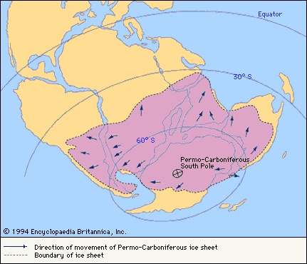
Extensive glaciation (glacier) persisted from the Carboniferous Period into the initial stage of the Early Permian Epoch over vast areas of present-day southern India, Australia, Antarctica, and northeastern Siberia. Middle Permian climates generally were warmer and moist. Climates of the Late Permian (Lopingian) Epoch were typically hot and locally very dry. Deserts became widespread in various tropical and subtropical areas during this time.The orogenies that marked the assembly of Pangea strongly influenced both climate and life. East-west atmospheric flow in the temperate and higher latitudes was disrupted by two high mountain chains—one in the tropics oriented east-west and one running north-south—that diverted warm marine air into higher latitudes. The continental collisions also closed various earlier marine seaways and isolated parts of the tropical shallow-water realms that were home to marine invertebrates. These realms eventually became endemic (regionally restricted) biological provinces.
Volcanism (volcano) may have strongly influenced climate at the end of the Permian Period. Extensive Siberian flood basalts (basalt) (the Siberian traps) in northeastern Siberia and adjacent western China erupted about 250,000,000 years ago and for about 600,000 years extruded 2,000,000 to 3,000,000 cu km (480,000 to 720,000 cu mi) of basalt. These eruptions contributed great amounts of volcanic ash to the atmosphere, probably darkening the skies and lowering the efficiency of plants in taking up carbon dioxide from the atmosphere during photosynthesis.
Permian life
Marine and terrestrial life
 Life during the Permian Period was very diverse—the marine life of the period was perhaps more diverse than that of modern times. The gradual climatic warming that took place during the Early Permian (Cisuralian) Epoch encouraged great evolutionary expansion (diversification) among both marine and terrestrial faunas that had survived the relatively cold conditions of the Carboniferous Period. Many lineages entering Early Permian times with only a few species and genera progressively diversified into new families and superfamilies as the climate warmed. Communities became increasingly complex, and generic diversity (diversity of organisms at genus level) increased through the midpoint of the Middle Permian (Guadalupian) Epoch. Within the tropical shallow-water marine communities, significant environmental changes occurring at the end of the Middle Permian Epoch were so abrupt that many groups became extinct, and only a few of the remaining groups survived into the Late Permian (Lopingian) Epoch.
Terrestrial life in Permian times was closely keyed to the evolution of terrestrial plants (plant), which were the primary food source for land animals. The fossil plant record for the Early Permian Epoch consists predominantly of ferns (fern), seed ferns (seed fern), and lycophytes (a group of vascular plants containing club mosses and scale trees), which were adapted to marshes and swampy environments. A less abundant Middle and Late Permian fossil record of early coniferophytes (a group of vascular plants containing cycads, ginkoes, and gnetophytes) and protoangiosperms (precursors to flowering plants) suggests a broad adaptation of these plant groups to progressively drier areas.
Evidence of broad plant diversification also is found in the rapid evolution of insects (insect), which quickly followed plants into new habitats. As these insects adapted to their new surroundings and formed very specialized associations with plants, many new species emerged. Permian insects included at least 23 orders, 11 of which are now extinct.
Emergence of important reptiles (reptile)
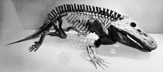
Several important reptile lineages, which descended from several orders of relatively large amphibians (amphibian), first appeared during the Permian Period. Although a few primitive and generalized reptile fossils are found in Carboniferous (Carboniferous Period) deposits, Permian reptile fossils are common in certain locations and include the protorosaurs, aquatic reptiles ancestral to archosaurs (dinosaurs, crocodiles, and birds); the captorhinomorphs, “stem reptiles” from which most other reptiles are thought to have evolved; eosuchians, early ancestors of the snakes and lizards; early anapsids, ancestors of turtles; early archosaurs (archosaur), ancestors of the large ruling reptiles of the Mesozoic (Mesozoic Era); and synapsids, a common and varied group of mammal-like reptiles that eventually gave rise to mammals in the Mesozoic.
Captorhinomorphs are common in Lower Permian beds of North America and Europe. Massively built and large for their day, they reached lengths of 2 to 3 m (about 7 to 10 ft). Captorhinomorphs are less common in Upper Permian beds, and only one small group survived into the Triassic Period.
 Synapsids (mammal-like reptiles) are divided into two orders: pelycosaurs and therapsids (therapsid). They show a remarkably complete transition in skeletal features from typical early reptiles (Early Permian Epoch) into true mammals (mammal) (in the Middle and Late Triassic epochs) through a fossil record lasting about 80 million years. The Early Permian pelycosaurs included carnivores and herbivores that developed long spines on their vertebrae (vertebrate) that supported a membrane, or “sail.” Pelycosaurs reached 3.5 m (about 11.5 ft) in length and had large, differentiated teeth. Their remains are common in the Lower Permian red beds of central Texas in North America but are rare in Europe.
Therapsids were advanced synapsids known from the Middle and Upper Permian and Triassic Karoo beds (Karoo System) of South Africa and equivalent beds in South America, India, Scotland, and Russia. Therapsids were highly diversified and had remarkably mammal-like dentition and bone structure. Their skeletal structures merge with early mammals with no apparent morphological breaks. The point at which mammal-like reptiles pass into mammals is generally placed at forms with cheek teeth having only two roots instead of three. The success of therapsids in the relatively high paleolatitudes of Gondwana has strengthened the view that they were able to maintain an elevated body temperature.
Mass extinction
Marine invertebrates
The greatest mass extinction episodes in Earth's history occurred in the latter part of the Permian Period. Shallow warm-water marine invertebrates show the most protracted and greatest extinctions during this time. Starting from the maximum number of different genera in the middle part of the Middle Permian Epoch, extinction within these invertebrate faunas significantly reduced the number of different genera by 12 to 70 percent by the beginning of the Capitanian Age (the latest age of the Middle Permian Epoch). The diversity levels of many of these faunas plummeted to levels lower than at any prior time in the Permian Period. Extinctions at the Middle Permian–Late Permian boundary were even more severe—bordering on catastrophic—with a reduction of 70 percent to 80 percent from the Middle Permian generic maxima. A great many invertebrate families, which were highly successful prior to these extinctions, were affected. By the early part of the Late Permian Epoch (specifically the Wuchiapingian Age), the now substantially reduced invertebrate fauna attempted to diversify again, but with limited success. Many were highly specialized groups, and more than half of these became extinct before the beginning of the Changhsingian Age (the final subdivision of the Late Permian Epoch). Late Permian faunas accounted for only about 10 percent or less of the Middle Permian faunal maxima—that is, about 90 percent of the Permian extinctions were accomplished before the start of the last age of the period (the Changhsingian Age).
The extinction events taking place during both the last stage of the Middle Permian Epoch and throughout the Late Permian Epoch, each apparently more severe than the previous one, extended over about 15 million years. Disruptive ecological changes eventually reduced marine invertebrates to crisis levels (about 5 percent of their Middle Permian maxima)—their lowest diversity since the end of the Ordovician Period. The final Permian extinction event, sometimes referred to as the terminal Permian crisis, while very real, took 15 million years to materialize and likely eliminated many ecologically struggling faunas that were already greatly reduced by previous extinctions.
Causes
Temperature crises
Although other single event causes have been suggested, current explanations of Permian extinction events have focused on how biological and physical causes disrupted nutrient cycles. Hypotheses of temperature crises, especially of those occurring in shallow marine (surface) waters, are based in part on studies of oxygen isotopes (isotope) and the ratios of calcium to magnesium in Permian fossil shell materials. The highest estimated temperatures of ocean surface waters (estimated to be 25–28 °C 【about 77–82 °F】) until that time occurred during the end of the Middle Permian and the beginning of the Late Permian Epoch. Subsequently, by the end of the Late Permian Epoch, calcium-to-magnesium ratios suggest that water temperatures may have dropped to about 22–24 °C (about 72–75 °F), decreasing further during the very beginning of the Triassic Period. One hypothesis proposes that water temperatures greater than 24–28 °C (about 75–82 °F) may have been too warm for many invertebrates; only those specialized for high temperatures, such as those living in shallow lagoons, survived.
Another temperature-related hypothesis posits that photosynthetic symbionts (symbiosis), which may have lived within the tissues of some marine invertebrates, were unable to survive the higher ocean temperatures and abandoned their hosts. Some of the data have been interpreted to show that an increase in seawater temperature of about 6 °C (10.8 °F) occurred—perhaps increasing the overall temperature of seawater to about 30–32 °C (about 86–90 °F)—near the Permian-Triassic boundary.
Alteration of the carbon cycle
The ratio between the stable isotopes of carbon (12C/13C) seems to indicate that significant changes in the carbon cycle took place starting about 500,000 to 1,000,000 years before the end of the Permian Period and crossing the boundary into the Induan Age (the first age of the Triassic Period). These changes appear to coincide closely with two Permian extinction events, suggesting some cause-and-effect relationship with changes in the carbon cycle.
Several studies have suggested that changes in the carbon isotope record may indicate a disrupted biological cycle. Some scientists consider the unusually high amounts of 12C trapped in Permian sediments to be a result of widespread oceanic anoxia (very low levels of dissolved oxygen). They associate this anoxia with the prolonged eruption of the Siberian flood basalts (basalt), which probably led to higher levels of carbon dioxide in the atmosphere. Clouds of volcanic ash may have worsened the situation by restricting the amount of sunlight available for photosynthesis, thereby inhibiting the process of carbon fixation by plants and lowering the extraction rate of carbon dioxide from the atmosphere. In addition, high amounts of carbon dioxide may have been injected into the atmosphere directly by the venting of volcanic gases from the eruption of flood basalts or indirectly by the ignition of forests by hot lava. Other hypotheses suggest that the warming and drying of the terrestrial environments during the Permian Period reduced the amount of organic matter buried in sediments as coal or petroleum, shifting the amount of organically fixed carbon dioxide that was recycled through the atmosphere.
Other potential causes
A few scientists have suggested that a large icy meteoritic (meteorite) impact caused a sudden cooling of the Earth, but such an impact lacks supporting evidence. A glacial episode at the end of the Permian has been suggested because of the general lowering of the sea level during the Late Permian Epoch. However, no Late Permian glacial deposits have been identified, despite extensive searching.
Permian geology
Major subdivisions
The Permian Period is subdivided into Early (Cisuralian), Middle (Guadalupian), and Late (Lopingian) epochs corresponding to the Cisuralian, Guadalupian, and Lopingian rock series. Rocks laid down during these epochs and ages have been assigned to corresponding depositional series and stages, respectively. The Cisuralian Epoch takes its name from its type region on the western slopes of the Ural Mountains in Russia and Kazakhstan and is subdivided into four internationally recognized ages: the Asselian (Asselian Stage) (299 million to 294.6 million years ago), Sakmarian (Sakmarian Stage) (294.6 million to 284.4 million years ago), Artinskian (Artinskian Stage) (284.4 million to 275.6 million years ago), and Kungurian (Kungurian Stage) (275.6 million to 270.6 million years ago). The Guadalupian Epoch takes its name from its type area in the Guadalupe Mountains of the West Texas region in the United States and contains three internationally recognized ages: the Roadian (270.6 million to 268 million years ago), Wordian (268 million to 265.8 million years ago), and Capitanian (265.8 million to 260.4 million years ago). The Lopingian Epoch takes its name from its type area in China and contains two internationally recognized ages: the Wuchiapingian (260.4 million to 253.8 million years ago) and Changhsingian (253.8 million to 251 million years ago). Lower Triassic beds overlie the Lopingian Series.The establishment of time equivalence of Permian strata between different areas has been a serious problem since the mid-19th century. Most Permian invertebrate faunas from marine environments are strongly endemic (localized in one or a few nearby areas) and thus difficult to correlate between different paleobiotic provinces. However, in the type regions of each of these series, all located within the paleoequatorial warm-water conodont (a primitive chordate with tooth-shaped fossil remains) province, a succession of these pelagic faunas continues to undergo description. While this will not lead to the global correlation of certain fossils, it is useful enough to define some regional patterns and assist in the general correlation of each particular rock series.
Subdivisions within the Permian Period are classified by the emergence of several species of conodonts. In the Cisuralian Series the first appearance of Streptognathodus isolatus marks the base of the Asselian Stage, the first appearance of Sweetognathus merrilli marks the base of the Sakmarian, Sweetognathus whitei and Mesogondolella bisselli mark the base of the Artinskian, and Neostreptognathodus pnevi and N. exculptus mark the base of the Kungurian. The first appearance of Jinogondolella nankingensis specifies the base of the Roadian Stage in the Guadalupian Series, the first appearance of Jinogondolella aserrata indicates the base of the Wordian, and the first appearance of Jinogondolella postserrata marks the base of the Capitanian. The emergence of Clarkina postbitteri marks the base of the Wuchiapingian Stage in the Lopingian Series; and the first appearance of Clarkina wangi characterizes the base of the Changhsingian. The base of the Triassic Period is indicated by the first appearance of Hindeodus parvus.
Different conodont zonations must be used for the colder waters surrounding Gondwana. These zones, which are in the process of being described and established, are based on different conodont species, and even different genera, from those found in the Northern Hemisphere. Even in the paleoequatorial belt, some of the conodont guide species do not appear in all areas, and certain successions of conodonts are rare (as in the sediments of the Tethys Sea) or do not appear at all. For these successions, local series and stage names remain useful, particularly in identifying different nonmarine successions.
Economic significance of Permian deposits
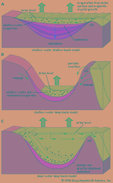 Permian rocks have long been economically important sources of evaporite minerals, such as halite (rock salt), sylvite (potash salts), gypsum and anhydrite (calcium sulfate salts), petroleum, and coal. The distribution of these resources, in part, is related to the latitudes where they were deposited. Evaporites were particularly common in subtropical and tropical Permian paleolatitudes in what is now West Texas, New Mexico, and Kansas in North America and in northwestern Europe and the European part of Russia. Thick coals (coal) formed in cool temperate paleolatitudes, such as central and northern Siberia, Manchuria, Korea, peninsular India, eastern Australia, South Africa, Zimbabwe, and the Congo. These locations lay in higher latitudes during the Permian Period.
Many Permian marine basins produce petroleum. The most famous oil fields are in the United States—in Oklahoma and the Permian Basin of West Texas and New Mexico—and along the Ural orogenic belt in Russia.
Phosphorites (phosphorite) (sedimentary rocks with economic amounts of various phosphate-bearing minerals) are common in Montana, Idaho, Wyoming, Utah, and Nevada. They were deposited in deepwater sedimentary wedges next to the Permian continental shelf margin at the western edge of the North American craton. In Europe, phosphorites occur along a deepwater trough marking the eastern edge of the Russian Platform.
Of significance to European civilizations is the Permian Kupferschiefer, a copper-bearing (copper) shale that has been mined for hundreds, perhaps even thousands, of years. In addition, pinnacle reefs composed of limestones from the Cisuralian Series occur along the southeastern margins of the Russian Platform. The Ishimbay oil fields of this region were a critical source of petroleum for the former Soviet Union during World War II after their fields to the west fell under German control.
Occurrence and distribution of Permian deposits
Permian rocks are common to all present-day continents; however, some have been moved—sometimes thousands of kilometres—from their original site of deposition by tectonic transport during the Mesozoic (Mesozoic Era) and Cenozoic (Cenozoic Era) eras. For example, Permian glacial terrestrial and marine deposits typical of the cold high latitudes of the Southern Hemisphere are now found in Antarctica, southern Africa, India, Thailand, and Tibet, and glacial deposits of the Northern Hemisphere laid down at that time are found in northeastern Siberia. By contrast, some Permian tropical and subtropical carbonate deposits, typical of deposition in low latitudes, were relocated to high latitudes. The present location of certain fossilized animals, endemic to the tropics during Permian time, suggests that other deposits were also moved great distances longitudinally (on a north-south axis). These deposits formed accreted terranes (smaller landmasses subsequently added onto continents) that became attached to the margins of some continents during Mesozoic and Cenozoic times. The present-day locations of Permian deposits are explained by the theory of plate tectonics. When the Permian globe is reconstructed, these apparent conflicts in rock deposition disappear, and a plausible arrangement of deposition, which is consistent with Permian climate patterns, emerges.
Carbonate (carbonate rock) provinces
Two tropical to subtropical carbonate provinces are recognized centred near the paleoequator but on opposite sides of Pangea. One includes the southwestern United States and northwestern South America. The other, which is much larger and has a more diverse fauna, includes the Tethys (Tethys Sea) belt of rocks from Tunisia and the Carnic Alps of present-day Italy and Austria on the west through Turkey, Iran, southern China, Southeast Asia, and Japan to central British Columbia, Washington, Oregon, and California. The Tethys carbonate province was thoroughly disrupted by orogenic (orogeny) deformation (as the result of seafloor spreading and plate tectonics) after the Permian Period ended. Thus, the remains now reside in almost entirely dislocated fragments.
Sediments in tectonically active regions
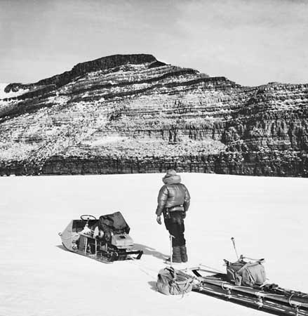 In terms of geologic setting, Permian sediments deposited as thick sedimentary (sedimentary rock) wedges along the tectonically active margins of the major cratons are least understood. Most of these Permian sediments have been thrust and involved in major geologic deformation. Much of the fossil evidence is from clastic material derived from shallow shelf environments or eroded from older rocks and deposited as deepwater debris fans. Thick deposits—perhaps originally 1 to 3 km (0.6 to 1.9 mi) thick—are known in central Nevada, Idaho, and northward into Canada. Similar deposits occur in the Middle East, China, Japan, and eastern Siberia.
Interleaved with these thick clastic wedges are other thrust slices of ocean-floor (ocean) deposits. These are thinner, about 0.5 km (0.3 mi) thick or less, and are characterized by radiolarian-rich cherts (chert and flint), basaltic volcanic dikes (dike), sills (sill), and submarine lava flows, as well as silts and clays of the distal ends of turbidity flows (ocean). All Permian (and older) ocean-floor deposits and thick sedimentary wedges have been caught up in Mesozoic and Cenozoic subduction zones (subduction zone) along plate boundaries and either form accretionary wedges or were lost to the Earth's mantle.
limestone
Associated with some oceanic basalts are thick accumulations of tropical and subtropical reef limestone that formed on seamounts (seamount) and volcanic island arcs (island arc). Because limestone is comparatively less dense than adjacent oceanic rocks, such as basalt or chert, many of the Permian reef limestones were not as readily subducted. They are present in many accretionary wedges, such as those found in Tunisia, the Balkan Peninsula, Turkey, the Crimea (in Ukraine), the Middle East, northern India, Pakistan, Southeast Asia, New Zealand, China, Japan, eastern Siberia, Alaska, the western Cordillera of Canada and the United States, and a small part of northwestern Mexico.
Other limestones were deposited as reefs along the outer margins of sedimentary basins. Striking examples of these reefs form the Guadalupe Mountains of western Texas and New Mexico. Such reefs also occur in the subsurface along the Central Basin Platform in western Texas, where they are a source of petroleum. Similar reefs are found in northern England, Germany, and the subsurface of the North Sea. Lower Permian limestone reefs are found in the western and southern Urals of eastern Europe.
Basin sedimentation
Cratonic (craton) shelf sedimentation in low paleolatitudes during Permian time was characterized by the gradual withdrawal of shorelines and the progressive increase in eolian (wind-transported) sands, red beds, and evaporites (evaporite). Many intracratonic basins—such as the Anadarko, Delaware, and Midland basins in the western United States; the Zechstein Basin of northwestern Europe; and the Kazan Basin of eastern Europe—show similar general changes. In most basins the inner parts became sites of red bed deposition during the Early Permian, followed by periods of extensive evaporite production. Sand sources along the ancestral Rocky Mountains supplied eolian sand and silt in great quantities.
The outer portions of the intracratonic basin systems, as in the Delaware and Zechstein basins, were involved in some transform faulting (process where two tectonic plates slide past one another) and extensional tectonics (the stretching and rifting of a continental plate), which produced landforms of considerable relief in some areas. Although some of this relief was from rotated fault blocks, most of it resulted from the very rapid growth of limestone reefs on upthrown blocks (that is, the sides of faults that appear to have moved upward) and the slower accumulation of clastic sediments on downthrown blocks.
At higher paleolatitudes, limestone is rare, and clastic rocks dominate the succession (the progressive sequence of rocks). Australia, Namibia, South Africa, peninsular India, southern Tibet, and southern Thailand all report Permo-Carboniferous tillite. These areas, as the paleogeographic reconstruction indicates, would have been in relatively high Gondwanan latitudes (closer to the South Pole) during the Permian Period, and thus their geology was affected by the expansion and contraction of glaciers. Tillites are also known from the northern high paleolatitudes in northeastern Siberia.
Some areas of Gondwana were tectonically active during Permian time, as evidenced by extensive basaltic (basalt), andesitic (andesite), and other volcanic rocks in eastern Australia. In addition, intracratonic sedimentary marine basins, such as the Carnarvon Basin in Western Australia, where nearly 5 km (3 mi) of Permian sediments accumulated, were formed.
Continental rocks were widespread on all cratons during the Permian Period. The Dunkard Group is a limnic (deposited in fresh water), coal-bearing succession that was deposited from the latest of Carboniferous times into Early Permian time along the western side of the then newly formed Appalachian Mountains. Coal-bearing Lower and Upper Permian beds—up to 3 km (1.9 mi) thick—are widely distributed in Australia, peninsular India (the lower part of the Gondwana System), southern Africa (the lower part of the Karoo System), the Kuznetsk Basin of western Siberia, the Paraná Basin of southern Brazil, and the Precordillera Basin of western Argentina. Red beds were common in the continental beds of tropical and subtropical paleolatitudes.
Correlation of Permian strata
Major subdivisions of the Permian Period are identified by extended periods of lowered sea level and by major faunal change. To overcome problems of shallow-water marine provincialism, biostratigraphers have increasingly turned to more open-ocean fossils, including cephalopods (cephalopod) (which also are surprisingly provincial) and conodonts (conodont) (which appear to be less provincial but whose biological affinities are poorly known).
Major boundaries and subdivisions of the Permian System
Early work
The history of the identification and acceptance of the Permian Period by geologists is in many ways the account of good deductive reasoning, a determined scientist, and an opportunity that was exploited to its fullest. Scottish geologist Roderick I. Murchison (Murchison, Sir Roderick Impey) had been aware that the Coal Measures (unit of stratigraphy equal to the Pennsylvanian Series (Pennsylvanian Subperiod) or Upper Carboniferous (Carboniferous Period) System) in northern England and Germany were overlain by red beds and poorly fossilized dolomitic (dolomite) limestones that had major unconformities at their base and top. Murchison reasoned that somewhere, perhaps outside northwestern Europe, a more complete stratigraphic succession would fill in these sedimentary gaps and would provide a more complete, better-preserved fossil assemblage.
In 1840 and 1841 Murchison found the missing stratigraphic succession in European Russia along the western flanks of the Ural Mountains, where he recognized a well-developed succession of rocks that both included rocks equivalent in age to the problematic red beds and dolomitic limestones of northwestern Europe and also filled the missing gaps below and above those sediments. He named these rocks the Permian System after the region of Perm, where they are particularly well developed.
Murchison included the red beds and evaporite beds now referred to as the Kungurian Stage in the lower part of his Permian System, while incorporating the nonmarine beds of the Tatarian Stage (a regional stage roughly equivalent to the Capitanian Stage plus a portion of the Wordian Stage) in its upper part. The upper portion of these nonmarine beds was subsequently shown to be Early Triassic (Triassic Period) in origin. The Ufimian-Kazanian Stage (a regional stage overlapping the current Roadian Stage and the remainder of the Wordian Stage) in between Murchison's upper and lower parts of the Permian System was considered to be a close lithologic and age equivalent of the Zechstein of northwestern Europe.
Later work
A symposium organized by the American Association of Petroleum Geologists in 1939 established North American standard reference sections for the Permian consisting of four series—namely, the Wolfcampian, Leonardian, Guadalupian, and Ochoan—on the basis of the succession in West Texas and New Mexico.
Attempts in the 1950s and ′60s to unify the nomenclature within the Permian System into two (upper and lower) series based primarily on the Russian Platform and Ural successions proved unsuccessful. Currently the Permian System is subdivided into three series with global reference sections based on the Russian Cisuralian succession for the Lower Series, the West Texas Guadalupian for the Middle Series, and the Chinese Lopingian for the Upper Series.
Regional stages were considered necessary and important because they were based on strongly provincial faunal zonations that differ markedly from one region to the next. Within a single region or faunal province, the similarity of the succession of fossils and patterns of rock deposition permits ready age correlations; however, age correlations from one region to the next are more difficult and open to more questions. This differentiation of provincial faunas and their isolation from one another increase noticeably in the middle and later parts of the Permian Period.
Permian-Triassic boundary
Except for the central and eastern parts of the Tethys region, where local deposition was apparently continuous, the boundary between the Permian System and the overlying Triassic System is a hiatus of one to several million years. Outside of the Tethys region, the boundary between these two important systems—indeed, the boundary between the Paleozoic and Mesozoic eras—has not been readily defined. The latest Permian faunas were reduced to only a few remnant genera that were sensitive to stressful new environments. Typical Triassic lineages were mostly relicts from the latest Permian.
Additional Reading
Permian life and extinctions are treated by Douglas H. Erwin, The Great Paleozoic Crisis: Life and Death in the Permian (1996); and Charles A. Ross and June R. P. Ross, “Permian,” in Richard A. Robison and Curt Teichert (eds.), Treatise on Invertebrate Paleontology, Part A, Introduction—Fossilization (Taphonomy), Biogeography, and Biostratigraphy (1979), pp. 291–350. P.A. Scholle, T.M. Peryt, and D.S. Ulmer-Scholle (eds.), The Permian of Northern Pangea, 2 vol. (1995), summarizes a wide diversity of geological information from many different points of view, attempting to clarify some of the stratigraphic questions, paleoclimatic interpretations, and stratigraphic evidence for the European and North American aspects of the supercontinent Pangea. Hongfu Yin (ed.), Permian-Triassic Evolution of Tethys and Western Circum-Pacific (2000), examines Permian and Triassic stratigraphy and paleontology in the vast Paleo-Tethys seaway of the time. Carol A. Hill, Geology of the Delaware Basin, Guadalupe, Apache, and Glass Mountains, New Mexico and West Texas (1996), highlights the geologists, geologic history, stratigraphy, geochemistry, and economic aspects of geology concerning this famous area of Permian sedimentation in the southwestern United States.
- watch
- watch fob
- water
- water beetle
- Waterberg Series
- water bloom
- water boatman
- waterbuck
- water buffalo
- Waterbury
- water chestnut
- water cock
- watercolour
- watercress
- waterfall
- water fern
- water flea
- Waterford
- Waterford glass
- waterfowl
- Watergate Scandal
- water glass
- water hemlock
- water hen
- Waterhouse, Alfred