San Juan
Argentina
city, capital of San Juan provincia (province), west-central Argentina. It lies along the San Juan River and is enclosed by Andean foothills on three sides. Founded in 1562 by Juan Jufré y Montesa, governor of the captaincy general of Cuyo, the city was moved in 1593 to its present site, 2 miles (3 km) south, because of floods; it is now protected by an embankment. Because it was on the fringe of Spanish-held territory, it was originally named San Juan de la Frontera. Early in the 18th century, Jesuits built a cathedral and a convent, both of which were destroyed, along with most of the city's other buildings, in a severe earthquake in 1944. Reconstruction has given San Juan a modern appearance.
The processing of meat, wines, fruits, and grains is the main economic activity. San Juan was the birthplace of Domingo Faustino Sarmiento (Sarmiento, Domingo Faustino) (Argentine educator and president from 1868 to 1874), and his home, which contains a museum and library, was declared a national monument in 1910. Pop. (2001) 112,778.
Dominican Republic
in full San Juan de la Maguana
city, southwestern Dominican Republic. It lies on the San Juan River, an affluent of the Yaque del Sur River, northwest of Santo Domingo city. The Spanish explorer Diego Velázquez founded San Juan in 1508 by royal decree on the site of the Taino Indian capital, then ruled by Chief Caonabo. The settlement floundered until 1764, when an influx of ranchers revitalized the area. During the early 19th century, San Juan witnessed a series of Dominican-Haitian battles, followed by Creole uprisings for independence from Spain. The Battle of Santomé (1844), which achieved Dominican independence, was fought nearby; it is commemorated by a monument. In addition to cattle, the economic activities of the city focus on the production of rice, coffee, corn (maize), fruit, and potatoes. Pop. (2002) urban area, 70,969.
Puerto Rico
Introduction
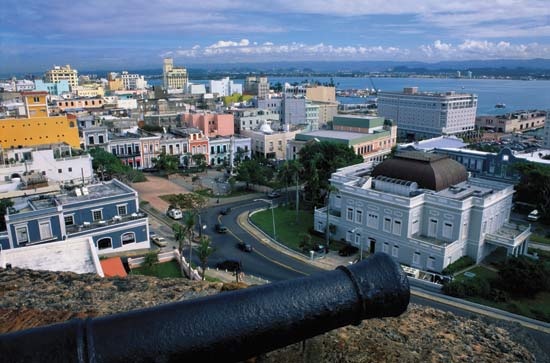
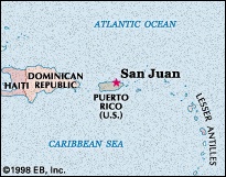
capital and largest city of Puerto Rico, located on the northern coast of the island on the Atlantic Ocean. A major port and tourist resort of the West Indies, it is the oldest city now under U.S. jurisdiction. Originally the settlement was known as Puerto Rico and the island as San Juan, but over the centuries common usage brought about a reversal of the names. Pop. (2006 est.) city, 426,618; (2000) urban agglom., 2,216,616.
History and architecture
In 1508 the Spanish explorer Juan Ponce de León (Ponce de León, Juan) founded the original settlement, Caparra, on the almost landlocked harbour just to the west of the present metropolitan area. In 1521 the settlement was moved to a rocky islet at the harbour entrance. Casa Blanca (“White House”) was begun that same year and was owned by Ponce de León's family until the late 18th century. In 1533 the Spanish began construction of massive fortifications in response to attacks by native Taino and by European powers. The bulwark-palace known as La Fortaleza, built near Casa Blanca, was the first of the new defenses (it now houses the governor's mansion). San Felipe del Morro castle (also called El Morro) was constructed next, on a high bluff overlooking San Juan Bay.
 In the early 16th century San Juan was the point of departure for Spanish expeditions to unknown parts of the New World. Its fortifications repulsed the English navigator Sir Francis Drake (Drake, Sir Francis) in 1595 as well as later attackers, but George Clifford, 3rd earl of Cumberland, captured it briefly in 1598, and a Dutch force took the city from the landward side in 1625. In response, the fortress of San Cristóbal, the largest Spanish fort in the New World, was built to the northeast, and, from 1634 to 1638, walls were erected across the southern part of the city, facing the harbour. The bastions existing today were largely added during the period 1765–83. In May 1898 the guns of San Cristóbal engaged a U.S. fleet that bombarded the city. Puerto Rico became a U.S. territory under the terms of the Treaty of Paris (Paris, Treaty of) that same year.
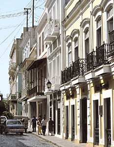
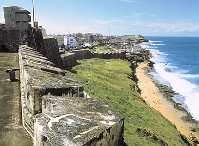 Ponce de León is buried in the San Juan Cathedral, which was begun in 1521 and rebuilt in 1540 and again in 1802. San José Church, begun in 1532, is the oldest church in continuous use in the Western Hemisphere. La Casa del Callejón (“House of the Narrow Street”) includes museums of colonial architecture and of Puerto Rican family life. La Casa del Libro (1955; “House of the Book”) is a rare-book library and museum housed in an 18th-century structure. Ponce de León's Casa Blanca has been converted into a historical museum, and another 18th-century house has become a museum preserving the manuscripts, personal effects, and instruments of Spanish cellist Pablo Casals (Casals, Pablo), who lived in Puerto Rico from 1956 to 1973. San Juan National Historic Site (1949) includes the El Morro and San Cristóbal fortifications; this area, along with La Fortaleza, was designated a UNESCO World Heritage site in 1983.
The contemporary city
 In the 20th century San Juan expanded rapidly beyond its walled confines (now known as Old San Juan) to incorporate suburban Miramar, Santurce, and Condado, along the coast, as well as industrial Hato Rey, with its large sports stadium and modern financial district, and the town of Río Piedras, immediately to the southeast. By 1980 the San Juan metropolitan area included the surrounding municipalities to the east and west and had about one-third of Puerto Rico's total population; that proportion has grown to two-thirds of the population. In a move to decentralize the old city, many government offices and agencies were moved across the bay, but the governor's palace has remained in use. Traffic congestion became a serious problem as the city grew, and, in an effort to reduce automobile use, the first line of a regional rapid-transit rail system opened in 2004.
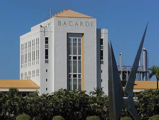 The San Juan metropolitan area is the largest industrial and processing centre of the island, with facilities for petroleum and sugar refining, tobacco processing, brewing, and rum distilling. Cement, pharmaceuticals, metal products, and clothing are also produced. San Juan is the island's financial capital, and many U.S. banks and corporations maintain offices or distributing centres there. Tourism is a major component of the local economy, visitors being drawn to the extensively restored Old San Juan district and the area's luxury resort hotels (particularly in Condado). The port of San Juan handles both cargo and a large number of cruise ships, and the city's international airport (named after Luis Muñoz Marín, the island's first elected governor) is just outside Old San Juan; both facilities are among the busiest in the Caribbean.
The main campus of the University of Puerto Rico (1903) is located in the Río Piedras barrio (ward) of San Juan. The medical campus and other facilities of the university also are located in San Juan. In 1957 the university became the home of the Casals Festival (now held in Santurce, San Juan's chief residential suburb), founded by Pablo Casals. The city's other educational institutions include the University of the Sacred Heart (1935) and a campus of the Inter-American University of Puerto Rico (1912). The Puerto Rico Museum of Art, combining a new five-story structure with a former hospital building, opened in 2000. Notable annual events in addition to the Casals Festival are the San Sebastian Street Festival in January and the San Juan Bautista (St. John the Baptist) Festival in June.
county, New Mexico, United States
county, northwestern New Mexico, U.S., bordered on the north by Colorado and on the west by Arizona; it also touches Utah at its northwestern tip at the only location in the United States (called the Four Corners) where four states meet. San Juan county is a scenic, semiarid area in the Navajo section of the Colorado Plateau. The centre of the county contains buttes, broken red sandstone mesas, angular volcanic rocks—including the landmark Ship Rock—and mountains rising dramatically from the basically flat landscape, with arroyos and canyons gouged by streams that have mostly dried up. The Chuska Mountains rise to more than 9,000 feet (2,700 m) in the southwest. The San Juan River, at Lake Navajo, forms the county's northeastern boundary, then receives the Las Animas River and flows in a long curve through the county. The western half of San Juan county is occupied by the Navajo Indian Reservation and, in a small area near Colorado, the Ute Mountain Indian Reservation. Chaco Culture National Historic Park, Aztec Ruins National Monument, Angel Peak State Recreation Area, and Navajo Lake State Park are all located in the county.
Ancestral Pueblo (Ancestral Pueblo culture) (Anasazi) peoples built the pueblo at Aztec Ruins National Monument early in the 12th century; by the 16th century, Pueblo and Navajo Indians were living in the region. War between Navajos and whites was intermittent for over two centuries. The Spanish, then the Americans forced Navajos into slavery, and in 1864 American soldiers led by Colonel Kit Carson forced over 7,000 Navajos to make the “long walk” to the notorious Bosque Redondo, where they lived under great privation. Four years later the vast Navajo reservation was established in New Mexico and Arizona. San Juan county was established in 1887.
The Navajo nation owns almost 60 percent of San Juan county and the U.S. government about 29 percent. In the 20th century, the production of coal, natural gas, and petroleum brought prosperity to the region. Federal expenditures and tourism also contribute to the economy. Aztec is the county seat, and the town of Bloomfield and the city of Farmington are other population centres. Area 5,514 square miles (14,282 square km). Pop. (2000) 113,801; (2007 est.) 122,427.
province, Argentina
provincia (province), west-central Argentina. It is separated from Chile on the west by the Andean cordillera, whose peaks average between 14,800 and 16,400 feet (4,500 and 5,000 metres) in elevation. Snow-fed rivers from the Andes dissect its mountainous western terrain. Three main rivers, the Bermejo, Jáchal, and San Juan, all used for irrigation, discharge into marshes in the semiarid southeastern portion of the province.
San Juan was settled in the late 16th and early 17th centuries by small numbers of Spanish agriculturists, Dominicans, and Jesuits from Chile. A part of the old Cuyo region, it remained a sparsely populated area exporting wine and dried fruits that were produced in its irrigated valleys. In 1776 control over San Juan passed from the Chilean captaincy general to the Río de la Plata viceroyalty. San Juan declared its own status as a province in 1825. The province was the epicentre of severe earthquakes in 1776, 1944, and 1977.
Grapes grown for both the table and wine occupy half of the cultivated land; olives, apples, barley, and onions are also raised, together with sheep and cattle. San Juan is rich in copper reserves but exploitation is limited. Economic activity in the city of San Juan, the capital of the province, and other urban centres is concentrated on food processing. The province is linked to Chile, with which much of its trade is carried on, by one local road across the Andes. Area 34,614 square miles (89,651 square km). Pop. (2001) 620,023.
- Intel Corporation
- intellectual disability
- intellectual-property law
- intelligence
- intelligence, human
- intelligence test
- intelligent design
- Intelsat
- intendant
- intendente
- intension and extension
- intensive agriculture
- intention
- intentional fallacy
- intentionality
- interactionism
- interactive multimedia
- Inter-American Development Bank
- Inter-American Regional Organization of Workers
- intercalation
- intercolumniation
- intercostalis muscle
- interdict
- interest
- interest group