Cairo
Egypt
Introduction
Arabic Al-Qāhirah (“The Victorious”)
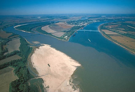
 city, capital of Egypt, and one of the largest cities in Africa. Cairo has stood for more than 1,000 years on the same site on the banks of the Nile (Nile River), primarily on the eastern shore, some 500 miles (800 km) downstream from the Aswān High Dam (Aswan High Dam). Located in the northeast of the country, Cairo is the gateway to the Nile delta, where the lower Nile separates into the Rosetta and Damietta branches. Metropolitan Cairo is made up of the Cairo muḥāfazah (governorate), as well as other districts, some of which belong to neighbouring governorates such as Al-Jīzah and Qalūbiyyah. Area governorate, 83 square miles (214 square km). Pop. (2006) governorate, 7,786,640; (2005 est.) urban agglom., 11,128,000.
Character of the city
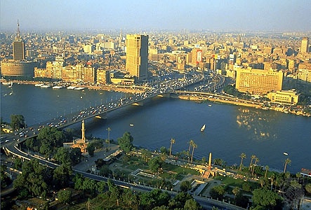
Cairo is a place of physical contrast. Along the well-irrigated shoreline, lush vegetation shares the landscape with tall skyscrapers. In the older inland quarters to the east, however, beneath the foothills of the Eastern Desert and the rocky promontories of the Muqaṭṭam Hills and the Al-Jabal al-Aḥmar (Arabic: Red Mountain), browns and ochres are the dominant hues of land and buildings.
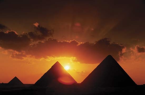 The city juxtaposes ancient and new, East and West. The Pyramids of Giza (Giza, Pyramids of), near Memphis, stand at the southwestern edge of the metropolis, and an obelisk in the northeast marks the site of Heliopolis, where Plato once studied; modern landmarks of Western-style high-rise hotels and apartment buildings overlook the Nile River. Between these extremes are other architectural monuments, dating from Roman, Arab, and Turkish times. In addition to department stores, cinemas, hotels, and town houses, Cairo contains a large functioning bazaar and an extensive, semi-walled medieval city endowed with more than 400 registered historic monuments—including mosques, mausoleums, and massive stone gates—dating to 130 CE.
Landscape
City site
Cairo is fan-shaped, narrowest in the south, where the river valley is wedged between desert escarpments, and widest in the north, where the valley blends into the delta. Over the centuries the city expanded westward, as a receding river channel left land flood-free. In response to heightened demand, however, the city also has been elongated to the north and south and has developed an expanding annex on the Nile's western shore.
Climate
Cairo has only two seasons: approximately eight months of summer and four months of winter. In the hottest of the summer months—June, July, and August—the average daily maximum temperature is 95 °F (35 °C), and the average daily minimum is 70 °F (21 °C). The summer temperature has reached as high as 117 °F (47 °C). During winter the strong Tropic of Cancer sun makes for warm, dry days, but nights are cool and humid, often freshened by breezes from the Nile. The average daily maximum temperature in January–February is 67 °F (19 °C), and the average daily minimum is 47 °F (8.5 °C).
City layout
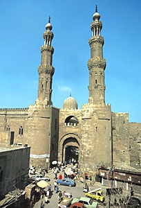
 The organization of the metropolitan complex is understandable only in the context of the city's history. The three oldest areas constitute densely populated poorer neighbourhoods that virtually surround a relatively Westernized downtown core. The largest of these is the medieval city built under the Fāṭimid (Fāṭimid Dynasty) dynasty (909–1171), with its pre-19th century extensions (Al-Jamāliyyah, Al-Darb al-Aḥmar, Bāb al-Shaʿriyyah, and Al-Sayyidah Zaynab toward the east and Al-Khalīfah toward the north). Situated within this densely settled zone are most of Cairo's historic monuments, including the Mosque of Baybars I at its northernmost edge and Saladin's Citadel in the south. Among the major bazaars within the central walled city is the Khān al-Khalīli, an expansive assortment of shops near al-Azhar Mosque, as well as various markets offering gold, copper ware, textiles, rugs, amber, spices, and leather goods. The major north-south thoroughfare is Shāriʿ al-Muʿizz li-Dīn Allāh, which bisects the old city and along which stand the major mosques and markets. Running perpendicular to this street is Shāriʿ al-Azhar; created in the 1920s to link the mosque of that name with Al-ʿAtabah al-Khaḍrā Square streetcar terminal, Shāriʿ al-Azhar now connects the old city with the central business district. Most other streets are narrow, twisting, and often dead-ended. The city's historic core was designated a UNESCO World Heritage (World Heritage site) site in 1979.
Two other old quarters, Būlāq (northwest of the medieval city) and Miṣr al-Qadīmah (“Old Cairo”; to the south), served as port suburbs of Cairo before the city expanded to encompass them. Būlāq, an island until 1340 and the city's main port by 1560, eventually became an industrial district in the early 19th century. In addition to its poorer neighbourhoods, the district is a centre for workshops, light industry, and trade schools. The mosques of Abū al-ʿAlāʾ and Sīnān Pasha are among the few historic buildings in Būlāq to survive a rapid gentrification process accompanied by the demolition of many of the older structures in order to make room for high-rise residential and commercial buildings. The origins of Miṣr al-Qadīmah lie with Al-Fusṭāṭ (Fusṭāṭ, Al-), originally founded as a military encampment in 641 by Amr ibn al-ʿĀṣʿ. At the heart of Miṣr al-Qadīmah stands the reconstructed Mosque of ʿAmr ibn al-ʿĀṣ (Amr ibn al-ʿĀṣ, Mosque ofʿ), as well as the many Coptic churches.
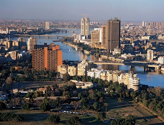 The central business district, referred to as the Wasṭ al-Balad (“city centre,” or downtown), is flanked by these older quarters. The Wasṭ al-Balad includes the older Al-Azbakiyyah district, Garden City, and, more recently, Jazīrah, the island offshore. The major thoroughfare connecting the city along its north-south axis is the Kūrnīsh al-Nīl (the Corniche), a highway paralleling the Nile River, built in the 1950s. Along the Corniche lie the Television Building, the Ministry of Foreign Affairs, and a number of hotels; in addition, the Egyptian Museum is nearby. Jazīrah, across the Nile from the Corniche, is the site of the Cairo Tower, public gardens, a racetrack, two major sporting clubs, several major hotels, and some of the city's most valuable real estate. Between the imposing Nile riverfront and the ancient inland quarters is a transitional working-class zone, chiefly developed in the 19th century; the National Library, the Museum of Islamic Art, and the presidential palace and archives later came to populate this region.
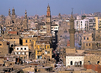 Along the eastern edge of the metropolis stands the district of Al-Qarāfah (City of the Dead), a unique zone made up of an extensive series of cemeteries. In this vast, dusty, ochre-coloured district stand the exquisite shrine-mosques and mausoleums of early religious leaders such as Imam al-Shāfiʿī (Shāfiʿī, Abū ʿAbd Allāh ash-), the founder of Egypt's major legal tradition. The major monuments of these eastern cemeteries are Mamlūk in design, each topped by a plain or fluted dome; lesser tombs are simpler, rectangular constructions. Owing to the rapid population growth that occurred following Egypt's independence in 1922, however, housing and shops have sprung up in the City of the Dead, where it is estimated that more than one million Cairenes live, many without municipal utilities or an official address.
The northern and western peripheries of the city grew dramatically in the last two decades of the 20th century. In Al-Jīzah (Giza) and on the island of Al-Rawḍah, on the Nile's western bank, are located residential quarters, the zoological and botanical gardens, an agricultural museum, and the campus of Cairo University. Workers' City (Madīnat al-ʿUmmāl) is a large-scale housing project in Imbābah, opposite Būlāq across the Nile, while Engineers' City (Madīnat al-Muhandisīn) has largely become the domain of Cairo's middle classes. Beginning in the mid-19th century, expansion toward the north led to development of the districts of Rawḍ al-Faraj, Shubrā, Sharābiyyah, Al-Qubbah, Al-ʿAbbāsiyyah, Al-Maṭariyyah, and Al-Zaytūn. Heliopolis, or Miṣr al-Jadīdah (“New Cairo”), became a major site of development in the 1970s and '80s, witnessing significant population growth and commercial expansion. Since that time, urban developments have increasingly encroached upon agricultural land, extending into the desert periphery; Heliopolis and Naṣr City (a suburb begun in 1958) are examples of such desert-based developments. A rural population still inhabits the northernmost fringe. Informal housing generally constitutes a considerable part of Cairo's residential districts.
Newer zones of Cairo's metropolitan area include a series of small satellite towns built in desert areas, including Madīnat al-ʿĀshir min Ramaḍān (10th of Ramadan City) to the east and Madīnat Sittah Uktūbar (6th of October City) to the southwest. Expensive gated communities have sprung up around the major highway leading to these developments. A number of sites-and-services housing projects, in which the government designs the subdivision and provides for streets, sewers, electricity, and water lines, also occupy a few satellite towns to the west and the south.
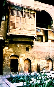 Building styles in Cairo are related to the historical period during which each quarter developed. In the oldest sections, two- to four-storied structures prevail, most built of fired brick covered with plaster and sometimes shored with half-timbering. A number of these have windows covered with delicately turned wooden lattices (mashrabiyyah; see moucharaby) and massive wooden doors elegantly decorated with inlay, brass, or iron nailheads. The traditional dwellings (of which only a few remain intact) open onto fountained courtyards and have separate quarters for men and women; the traditional workshops and warehouse inns (khans) have galleries overlooking their interior courtyards.
Parts of Cairo built in the 19th century reveal exaggerated European influences—highly ornate stone exteriors, cupolas, and Romanesque doorways. While this ungainly and incongruous style, darkened with time, predominates in the transitional zone, perhaps the most outlandish examples are the later Palace of Sakākīnī and the palace of Baron Empain, founder of Heliopolis. In the early modern quarters, built in the 20th century, the architectural style is partly Parisian, with most of the moderately tall buildings constructed of concrete slabs. Architecture closer to the Nile is marked by a mixture of styles, though concrete structures with balconies and glass curtain walls predominate there.
In the quarters on the west and north the more elegant districts have both handsome high-rise apartments and one- or two-storied “villas,” with high walls enclosing colourful gardens. Lower middle- and working-class housing consists exclusively of concrete multi-flat walk-up structures, gray or yellow-beige in colour, often with shops occupying the ground floor. The poorest zones contain similar structures, informal housing that is often left unfinished on the exterior.
In most quarters, commercial and industrial workshops are scattered among the dwellings; this is particularly the case in the poorer neighbourhoods. Houses on the rural fringe areas of Cairo are typically built of mud or fired brick, resembling traditional village housing in the hinterland.
People
Cairo's population, once both ethnically and religiously diverse, is now predominantly Muslim. A significant number of Egyptian Christians, the majority of whom observe the Coptic Orthodox (Coptic Orthodox Church of Alexandria) faith, continue to dominate certain districts in the city. Remnants of the old Italian, Greek, Syrian, and Sudanese communities are still found in some locations. Differences of status within the Egyptian population depend largely on one's place of origin (many residents of Cairo were born in rural Egypt), class, and degree of modernity. About half of the city's population live in the city proper, while half live in the suburbs.
Economy
Manufacturing
From its inception, Cairo's economy has been based on governmental functions, commerce, trade, and industrial production. The modern productive sector has expanded dramatically since the middle of the 20th century. Since the 1952 revolution, large-scale industrialization has built upon previous developments in textiles (utilizing the long-staple cotton for which Egypt is famous) and food processing (which consists of canning and freezing the wide variety of fruits and vegetables grown in the fertile delta), as well as the processing of sugarcane grown in Upper Egypt. In addition to the production of iron and steel, consumer goods, particularly appliances, are manufactured in nearby factories.
Finance and other services
Cairo is the country's primary centre for economic production and financial control. It still contains many of Egypt's important banks, hotels, restaurants, entertainment venues, and cafés.
About half of Cairo's predominantly male labour force works on the assembly lines and in the auxiliary commercial and financial institutions in the expanding formal sector of Cairo's modern economy. Nevertheless, substantial informal and traditional sectors still survive in which craftsmanship and personal relationships play an important role.
By the 1990s, with an improving infrastructure and a growing tourist industry, Cairo had begun promoting itself as a premier conference and convention centre. Numerous international events are held in the city.
Transportation
Egypt's extensive transportation network, laid out by the British, connects most of the country's urban centres with the capital. Within metropolitan Cairo, the transportation network is made up of both formal and informal sectors. The Public Transport Authority runs a bus network, which was introduced in the 1950s. In addition, a far-reaching system of authorized, licensed cabs operates in the city. Informal transportation services include minibuses and taxis, which sprang up in the late 1970s and '80s; these continue to predominate, particularly in areas that serve the expanding informal neighbourhoods. The Cairo Metro, a citywide subway system, began service in 1987 and has since been significantly expanded.
Traffic congestion is a serious problem in Cairo, particularly as both imports and local assembly plants have provided greater access to automobiles. To combat congestion and pollution, the Egyptian government built a substantial number of bypass highways and overpasses. Donkey-drawn carts, though technically outlawed, are also a common sight on Cairo's streets, operating among the city's automobiles, minibuses, buses, streetcars, and trolleys.
Administration and society
Government
Throughout its history, Cairo was administered by a combination of national policy makers and local administrators. In 1949 the municipality (baladiyyah) of Cairo was created; it was inaugurated, together with a town council, in 1950. In the following decade, Cairo was designated a governorate, with which the municipality was merged.
The boundaries of the Cairo governorate encompass only half of the urbanized metropolitan area; Ḥulwān, an industrial satellite in the extreme south, is included, but industrial satellites in the far north, such as Shubrā al-Khaymah, and the heavily developed quarters on the west bank form parts of other governorates.
At the head of the governorate of Cairo is the governor, who is appointed by the president. The governor is assisted by an executive committee, which includes undersecretaries from the major national ministries, such as the ministries of education, housing, health, social affairs, finance, and the interior. The Municipal Council of Cairo (Majlis Muḥāfaẓat al-Qāhirah), consisting of both elected representatives and ex officio members, was dissolved in 1971 and replaced by the Popular Assembly (al-Majlis al-Shaʿbī). The national government still maintains financial control over local programs and budgets, but the governorate's policies are directed by an Assembly (al-Majlis al-Shaʿbī al-Maḥalī 【Majlis Maḥalī】) consisting of a number of elected representatives.
Municipal services
Gas and water systems have existed since the 1860s and electrical and sewerage systems since the early 20th century. Most of the city's formal housing is connected to the electrical grid and the water and sewage networks. Cairo has a significant informal housing sector, however, and many of these structures are not served by utilities. Drinking water in the city is generally Nile water that has been filtered and purified. The telephone network was introduced in the 1920s, and a new telephone grid was integrated in the mid-1980s.
Health
Many of Egypt's health and medical facilities are concentrated in Cairo. During the 1950s and '60s, public hospitals were introduced under Pres. Gamal Abdel Nasser's socialist regime. Private hospitals proliferated in the 1980s and '90s, though much of Cairo's urban poor continue to have limited access to public health care services.
Education
Primary education is compulsory. In addition to primary and secondary schools, the city's educational facilities also include technical institutes. Foreign schools, common in the 1940s and '50s, were largely taken over by the government in the '60s. In the 1990s private schools proliferated, largely responding to the failures of state-run education.
Cairo is a major centre of higher education. The various faculties of Cairo University (1908) produce the country's largest number of college graduates and specialized professionals, including doctors, lawyers, and engineers. ʿAyn Shams University (1950) is also a notable institution, and al-Azhar University (Azhar University, al-), founded in the 10th century and previously specializing chiefly in language, literature, and religious subjects, has begun offering a number of additional courses of study, including engineering, commerce, and the social sciences. The American University in Cairo (1919) offers instruction in English in many disciplines. Miṣr University for Science and Technology (1996) was one of several private universities that opened during the late 20th and early 21st centuries.
Cultural life
Cairo has long been a cultural capital of the Middle East, as well as the region's chief mass media centre. For many centuries it was also the site of the region's major religious and cultural institutions. During the 19th century a number of European cultural institutions, such as theatres, were introduced. The original Baroque Opera House, situated on Opera Square in downtown Cairo, was destroyed by fire in 1971; it was replaced by a modern structure on the southern tip of Jazīrah, completed in 1988.
Egypt has long been known for its musical and dramatic talent and as the site of a renaissance in Arab theatre. The majority of Arabic films are produced by Egyptian companies in Cairo, and leading cinema stars and many popular musical entertainers of the Arab world make Cairo their headquarters. Egyptian radio and television series are broadcast throughout the Arab world, and a number of important newspapers are published in Cairo. Among the oldest and most widely circulated of these is Al-Ahrām (Ahram, Al-), established in 1875, although other dailies headquartered in the city—including Al-Jumhūriyyah, Al-Akhbār, and Al-Masāʾ—enjoy large readerships as well.
 Cairene and Egyptian heritage are represented in the collections of the city's rich series of museums. Located on Al-Taḥrīr Square, the Egyptian Museum displays a vast collection of antiquities, among them the treasures of Tutankhamen; the Coptic Museum in Miṣr al-Qadīmah specializes in pre-Islamic icons, textiles, and stones, and the Museum of Islamic Art in Bāb al-Khalq displays Mamlūk Qurʾāns (Qurʾān) and objects of wood, brass, inlay, and glass. The War Museum, located at the Citadel, is also in Cairo, and the Turkish-style Manyāl Palace Museum stands on the island of Al-Rawḍah. The mosques of Cairo themselves often offer as rich a historical store as the city's museums.
The Cairo Zoological Gardens, in Al-Jīzah, contain extensive collections of rare tropical animals in a garden setting. In addition to the sporting facilities on Jazīrah, including racetracks, swimming clubs, and gardens, there is a racetrack at Heliopolis. Naṣr City is the site of the Cairo Stadium and has numerous playing fields. Other recreation and entertainment options include sailboat trips up the Nile, as well as numerous riverfront cafés, restaurant boats, and nightclubs.
History
The early period
 Some 5,000 years ago Memphis—today lying mainly in ruins approximately 15 miles (24 km) southwest of Cairo—was a thriving metropolis; about 2,000 years ago the Romans occupied a town on the site of present-day Cairo called Babylon (later the Miṣr al-Qadīmah quarter). The seed from which contemporary Cairo later sprang was the town of Al-Fusṭāṭ (Fusṭāṭ, Al-), founded as a military encampment in 641 CE by ʿAmr ibn al-ʿĀṣ, an Arab general and administrator who brought Islam to Egypt. Successive dynasties added royal suburbs (including Al-ʿAskar, founded in 750 by the Umayyads (Umayyad Dynasty), and Al-Qaṭāʾiʿ, founded in 870 by Aḥmad ibn Ṭūlūn) to the increasingly prosperous commercial and industrial port city of Al-Fusṭāṭ. Little remains of these early developments in the southern part of the city, except the tower of Trajan (dating to 130 CE), the mosques of ʿAmr ibn al-ʿĀṣ (founded in 641–642) and Aḥmad ibn Ṭūlūn (Aḥmad ibn Ṭūlūn, Mosque of) (completed in 878), and the partially excavated mounds covering the site of Al-Fusṭāṭ.
In 969 the Fāṭimids (Fāṭimid Dynasty), adherents of a Shīʿite sect (see Ismāʿīliyyah (Ismāʿīliyyah, Al-)) and opponents of Sunni (Sunnite) ʿAbbāsid (Abbāsid Dynastyʿ) rule, invaded Egypt. The conquering general, Jawhar, established a new, rectangular, walled city to the northeast of the existing settlements. Initially named Al-Manṣūriyyah, the city was given its present name, Al-Qāhirah (“The Victorious”), in 973/974 in celebration of the arrival of the Fāṭimid caliph al-Muʿizz (Muʿizz, al-), who made the city the capital centre of a dynasty that lasted for two centuries. Al-Qāhirah and Al-Fusṭāṭ coexisted until 1168, when the unfortified city of Al-Fusṭāṭ was set on fire to protect Cairo from the Crusaders. The Crusaders were driven off by a Sunni army from Syria, after which the victorious commander, Saladin, founded the Ayyūbid dynasty, subsequently controlling a vast empire from Cairo.

 Although Al-Fusṭāṭ was partially rebuilt, it was Cairo that was transformed from a royal enclave into an imperial metropolis. Saladin further extended the city's 11th-century walls, of which the northern and southern walls and three main gates—Bāb al-Futūḥ, Bāb al-Naṣr, and Bāb Zuwaylah—are still extant; he also constructed a citadel on the Muqaṭṭam spur (now dominated by the Muḥammad ʿAlī Mosque). After Baybars I became the first Mamlūk sultan of undisputed legitimacy in 1260, Cairo served as the capital of the Mamlūk empire, which governed Egypt, much of the Levant, and parts of the Fertile Crescent until 1517.
Medieval Cairo reached its apogee during the Mamlūk era. By about 1340 Cairo had become the largest city in Africa, Europe, and Asia Minor, with almost half a million people living in an area five times greater than the original Fāṭimid walled city. As a key link in the profitable east-west spice trade and the recipient of tribute from a wealthy empire, the city thrived both intellectually and culturally: the venerable al-Azhar University (Azhar University, al-)—a principal seat of Islamic learning—as well as most of the city's greatest architectural masterpieces were built during this period.
 In the mid-14th century, decline set in—sporadically at first and then more precipitously. The city's population was decimated by plagues, including the outbreak of the Black Death in 1348. In addition, the spice trade monopoly was broken following Vasco da Gama (Gama, Vasco da)'s voyage from Portugal to India (1497–99), undermining Cairo's economic preeminence. Finally, political autonomy was lost to the Turks, who after 1517 reduced Cairo to a provincial capital in the Ottoman Empire. In 1798, when Napoleon (Napoleon I) and his troops arrived in Cairo, fewer than 300,000 people were living in the city and its two port suburbs, Miṣr al-Qadīmah and Būlāq.
Development of the city
Muḥammad ʿAlī, sent to Egypt in command of an Ottoman expeditionary contingent to oppose the French, had by 1805 succeeded in receiving the appointments of viceroy and pasha of Egypt from the Ottoman government. During a rule of more than 40 years, Muḥammad ʿAlī executed a series of sweeping programs, including the reorganization of the administrative structure, the improvement of irrigation systems, and the introduction of cotton, a commodity which Egypt would soon produce and trade on a large scale.
Modern urban growth in Cairo began in the 1830s, but it was only during Ismāʿīl's (Ismāʿīl Pasha) reign (1863–79) that the city was fundamentally transformed. Influenced by Baron Haussmann (Haussmann, Georges-Eugène, Baron)'s renovation of Paris, Ismāʿīl ordered the construction of a European-style city to the west of the medieval core. French city-planning methods dominated the design of the districts of Al-Azbakiyyah (with its large park), ʿAbdīn, and Ismāʿīliyyah—all now central zones of contemporary Cairo. By the end of the 19th century these districts were well-developed, but with the beginning of British rule of Egypt in 1882 they were transformed into a colonial enclave.
Awarded the right to hereditary rule of Egypt and the Sudan in 1841, Muḥammad ʿAlī founded the dynasty that governed Egypt without interruption until 1952, when Egypt's last king, Farouk I, was forced to abdicate by a military revolt led by Gamal Abdel Nasser (Nasser, Gamal Abdel). With the abolition of the monarchy, Egypt became a republic headed by a president.
After the 1950s, Cairo and its metropolitan area witnessed a significant period of growth. Improvements in transportation fostered the growth of suburban Heliopolis and Al-Maʿādī; flood control permitted riverfront development; and bridges encouraged settlement of islands (Al-Rawḍah and Al-Zamālik) and of the west bank. By 1970, however, the city was suffering from overcrowding, severe traffic congestion, and acute pollution. Further, fueled by industrialization, the city had been growing northward since the 1950s into the fertile delta, resulting in the consumption of valuable farmland. To combat this uneven sprawl, in the 1970s the government began developing new towns and planned suburbs in the desert, such as Madīnat al-ʿĀshir min Ramaḍān, Madīnat Sittah Uktūbar, and Madīnat al-Sādāt.
By the beginning of the 21st century, Cairo had become an increasingly stratified city, with large areas of informal housing occupied by the lower and middle classes and gated communities serving the upper classes. Although Cairo continues to be faced with many of the same problems afflicting other large metropolises in the developing world—particularly the problem of providing transportation and other infrastructural services to its greatly expanded population—it nevertheless remains among the world's most vibrant cities.
Additional Reading
Guidebooks of Cairo include Claire E. Francy (compiler), Cairo: The Practical Guide, new rev. ed., updated and edited by Lesley Lababidi (2006); and Caroline Williams, Islamic Monuments in Cairo: The Practical Guide, new rev. ed., 5th ed. (2002). One of the most authoritative, scholarly works on Cairo remains Janet L. Abu-Lughod, Cairo: 1001 Years of the City Victorious (1971). Other works of significance include Galila El Kadi and Alain Bonnamy, Architecture for the Dead: Cairo's Medieval Necropolis (2007; originally published in French, 2001); Maria Golia, Cairo: City of Sand (2004); André Raymond, Cairo (2000; originally published in French, 1993); Max Rodenbeck, Cairo: The City Victorious (1999); Nezar AlSayyad, Cities and Caliphs: On the Genesis of Arab Muslim Urbanism (1991), and Streets of Islamic Cairo: A Configuration of Urban Themes and Patterns (1981); Carl F. Petry, The Civilian Elite of Cairo in the Later Middle Ages (1981); Malise Ruthven et al., Cairo (1980), and Cairo: A Life-Story of 1000 Years, 969–1969 (1969). Additional works that remain important include James Aldridge, Cairo (1969); Desmond Stewart, Cairo: 5500 Years (1968; also published as Great Cairo, Mother of the World, 3rd ed., 1996), and Stanley Lane-Poole, The Story of Cairo (1902, reprinted 1971).
Illinois, United States
 city, seat (1860) of Alexander county, extreme southern Illinois, U.S. The city stands on a low-lying delta at the confluence of the Mississippi (Mississippi River) and Ohio (Ohio River) rivers. Bridges over both rivers connect the city with Kentucky (east) and Missouri (west). Cairo was so named because its site was thought to resemble that of the Egyptian city (see Cairo), and southern Illinois consequently became known as Little Egypt.
Cairo and the Bank of Cairo were chartered in 1818, when there was no settlement and there were no depositors. A second and successful attempt at establishing a town was made in 1836–37 by the Cairo City and Canal Company, which built a large levee that encircled the city; however, the settlement collapsed in 1840. Cairo was visited in 1842 by Charles Dickens (Dickens, Charles), who was not impressed and made it the prototype for the nightmare City of Eden in his novel Martin Chuzzlewit (1843–44). In 1846, 10,000 acres (4,000 hectares) of the site were purchased by the trustees of the Cairo City Property Trust, a group of Eastern investors who were interested in making the town the terminus of the projected Illinois Central Railroad; the railroad arrived in 1855. A city charter was obtained in 1857, and Cairo flourished as trade with Chicago spurred development. Cairo was headquarters for General Ulysses S. Grant (Grant, Ulysses S.) during the western campaigns of the American Civil War. Grant's presence forced much of the city's trade to be diverted to Chicago. Cairo failed to regain much of the trade lost during the war, and agriculture and lumber and sawmills subsequently came to dominate the economy. The city was protected by its levees from destruction when the Ohio River rose to record heights during the 1937 flood. In the late 1960s and early 1970s Cairo was the scene of racial strife, and it fell into a serious decline thereafter.
 Local industries include the production of pulp and paper and the manufacture of polyurethane foam and pet products. Notable attractions include the Custom House (1872), which is now a local museum, and the mansions along “Millionaire's Row,” including Magnolia Manor (1869), a five-story Italianate building. Fort Defiance State Park, site of the Civil War garrison, is just south; Mound City National Cemetery, just north of Cairo, contains thousands of Civil War graves. Horseshoe Lake Conservation Area and Shawnee National Forest are northwest of the city. Inc. 1818; reinc. 1857. Pop. (1990) 4,846; (2000) 3,632.
- Dominion Arboretum and Botanic Garden, Central Experimental Farm
- Dominique Cassini, comte de
- Dominique-Catherine, marquis de Pérignon
- Dominique-Catherine Pérignon, marquis de
- Dominique, comte de Cassini
- Dominique de Villepin
- Dominique-Jean, Baron Larrey
- Dominique-Jean Larrey, Baron
- Dominique Pire
- Dominique-René, Count d'Unebourg Vandamme
- Dominique-René Vandamme, Count d'Unebourg
- Dominique Rolin
- Dominique Vivant, Baron Denon
- Dominique Vivant Denon, Baron
- domino
- Domino, Fats
- domino theory
- domino whist
- dominus
- Domitian
- Domitien, Elisabeth
- Dom Joseph Pothier
- Dom Mintoff
- domovoy
- Domrémy-la-Pucelle