Capitol Reef National Park
park, Utah, United States
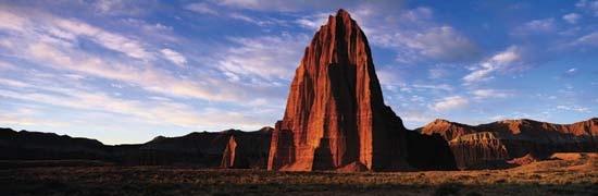 long, narrow area of imposing sandstone formations in south-central Utah, U.S., just east of Torrey. Established as a national monument in 1937, it became a national park in 1971. Grand Staircase–Escalante National Monument and Glen Canyon National Recreation Area are adjacent to it on the southwest and south, respectively. The park, which occupies 378 square miles (979 square km), was named Capitol Reef because its rock towers and pinnacles were reminiscent of coral reefs and its dome-shaped formations of the Capitol at Washington, D.C.
The park lies along the northwestern edge of the Colorado Plateau. It comprises great buttressed cliffs of coloured Navajo sandstone extending for 100 miles (160 km) along the western edge of the Waterpocket Fold. The fold was formed when thick layers of sedimentary rocks were flexed, or bent, during the uplift of the plateau some 65 million years ago. The erosion by wind and water of the uppermost layers of the folded rock formed the cliffs, pinnacles, towers, arches, and domes for which the park is noted. The Fremont River and its tributaries, Sulphur and Pleasant creeks, cross the formations through deep canyons that rise to more than 1,000 feet (300 metres).
Much of the park has sparse desertlike vegetation, including piñon pines and junipers on the talus slopes, but cottonwoods, willows, and a profusion of other vegetation grow along the streams. Wildlife ranges from small lizards to mule deer and bighorn sheep; birdlife includes golden eagles, hawks, and numerous songbirds. Some of the smooth cliff walls of the park are covered with pre-Columbian petroglyphs, created by people who lived in the area from about AD 700 to about 1300. The remnants of the now-deserted Mormon community of Fruita, including a schoolhouse and orchards, also are within the park.
- Edward O. Wilson
- Edward Patrick Morris, 1st Baron Morris
- Edward Patrick Morris Morris, 1st Baron
- Edward P. Jones
- Edward Preble
- Edward Prentiss Costigan
- Edward Randolph
- Edward Reilly, Jr. Stettinius
- Edward Reilly Stettinius, Jr.
- Edward Reynolds Pease
- Edward Riley Bradley
- Edward R Murrow
- Edward Robinson
- Edward Said
- Edwards, Alfred George
- Edward Samuel Corwin
- Edward Sapir
- Edwards, Gareth
- Edwards, John
- Edwards, Jonathan
- Edwards, Jorge
- Edwards, Lewis
- Edward Somerset, 2nd Marquess of Worcester
- Edward Somerset Worcester, 2nd Marquess of
- Edwards, Sir Owen Morgan