planation surface
geology
Introduction
any low-relief plain cutting across varied rocks and structures. Among the most common landscapes on Earth, planation surfaces include pediments, pediplains, etchplains, and peneplains. There has been much scientific controversy over the origins of such surfaces. Because genetic implications are so often associated with various names, it seems best to refer to these features as simply planation surfaces.
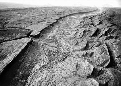 Figure 1--> shows a spectacular planation surface that bevels sandstone cuestas in the James Range in central Australia. Clearly an erosive process cut across rocks of varying resistance. The rock structure would never have developed such a flat surface unless a lateral erosive process had been at work in the past at a particular base level. Where many beveled cuestas of this sort line up at the same approximate elevation, they define the regional planation surface.Planation surfaces, such as that shown in Figure 1-->, are especially common in the ancient, tectonically stable land masses of the Southern Hemisphere. The South African geomorphologist Lester C. King identified several phases of cyclic planation, which he correlated on a global basis. The oldest surfaces he recognized, termed Gondwana, were Mesozoic in age and related to the ancient landmass of Pangaea and its subsequent breakup during the Mesozoic. A younger surface, called the African or Moorland, developed during the Late Cretaceous and Early Cenozoic by the stripping of weathered materials from the ancient Gondwana surfaces. Younger surfaces developed during the Late Tertiary and Pleistocene as incomplete planation at levels below the remnants of the ancient plains.
Pediments (pediment)
The portion of a plain adjacent to mountain slopes is known as a piedmont. In desert regions the characteristic faceted slopes of the mountain front result in a pronounced juncture of mountain and piedmont, the piedmont angle. Where piedmonts have experienced extensive erosion, often to a degree that bedrock is exposed, they constitute pediments. There may be a veneer of alluvium over the erosional surface, particularly where soft rocks (e.g., shales) occur on the piedmont. Massive rocks, such as granite, may develop spectacular bare-rock pediments that sharply mark a mountain front.
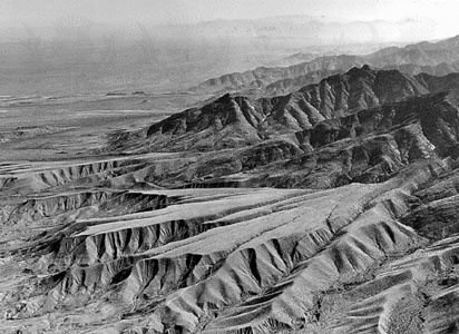 Pediments probably develop through a complex of processes, including the backwearing of the front slopes of a mountain, mantling and weathering of the pediment surface, and removal of weathered mantles by fluvial and slope processes. In many cases, the erosional history of the pediment does not allow for the preservation of diagnostic evidence as to its origin. Pediments are most common in areas where tectonism is relatively slow, since rapid uplift increases the capability of streams to deliver sediment to piedmont areas, leading to a dominance of deposition over erosion. In nature, the distinction between depositional piedmont landforms (alluvial fans) and erosional ones (pediments) is often unclear. The history of a piedmont influenced by climatic and tectonic changes is almost certainly to be marked by changes in the relative erosional or depositional character. A common situation is to find ancient pediments that were once mantled with fluvial deposits (they may have constituted fans) and that were subsequently left as relict forms when mountain front streams incised the surface (Figure 2-->).
The growth of pediments at the expense of the mountain mass results in retreat of the mountain front. For a small mountain range in an area of tectonic stability, the entire range may be eroded. This leaves a dome-like surface composed of the coalesced pediments. Cima Dome in the eastern Mojave Desert of California is an excellent example of this advanced stage of planation.
Pediplain
Where pedimentation occurs over broad regions, the coalesced surface is termed a pediplain. King believed that this process was responsible for many of the ancient planation surfaces of the world. Most geomorphologists, however, consider pedimentation to be a local process at mountain fronts, perhaps capable of generating planation surfaces for an individual mountain range but not uniquely the cause of globally correlated surfaces.
Etchplain
Where deep weathering occurs on a landscape, a dichotomy is set up between the thick regolith of weak, weathered rock and the underlying zone of intact rock. If subsequent erosion removes the weathered regolith, then a new planation surface develops through exposure of the old weathering front. This process often results in the exposure of structurally defined compartments of resistant rock. A subsurface landscape is essentially etched from the rock by deep weathering and subsequent removal of weathered products.
Etchplanation appears to have been especially characteristic of the ancient, stable cratonic areas of Gondwanaland (Gondwana), the supercontinent that many researchers believe once existed in the Southern Hemisphere. Deep weathering, generally tropical laterization, occurred through the Mesozoic and Early Tertiary. Great planation surfaces developed as tectonic factors influenced the periodic removal of weathering products.
peneplain
The concept of a peneplain (the word meaning “almost a plain”) emerged from W.M. Davis' cyclic view of landscape evolution. As rivers and hillslopes reduced relief through the phases of youth, maturity, and old age, explained Davis, the eventual result was a plain of extremely low relief. This plain could only change very slowly, since potential energy for fluvial action was greatly reduced. Such a peneplain, as with any planation surface, could become relict when renewed uplift induced stream incision below its former position on the plain.
Because it is tied genetically to the Davisian theory of landscape development, the concept of peneplains is rarely used in modern geomorphology. There is, however, frequent reference to peneplanation in older literature. For modern applications, it is best to use a purely descriptive term such as planation surface or erosion surface for features that were formerly classified as peneplains.
Additional Reading
See George F. Adams (ed.), Planation Surfaces: Peneplains, Pediplains, and Etchplains (1975).
- Herman De Valenciennes
- Herman Francis Mark
- Herman Frasch
- Herman Gorter
- Herman Harrell Horne
- Herman Haupt
- Herman Heijermans
- Herman Hollerith
- Herman Kahn
- Herman Mankiewicz
- Herman Melville
- Herman Miller, Inc.
- Hermann Alexander, Graf von Keyserling
- Hermann Alexander Keyserling, Graf von
- Hermann Bahr
- Hermann Boerhaave
- Hermann Broch
- Hermann Busenbaum
- Hermann Cohen
- Hermann Collitz
- Hermann Ebbinghaus
- Hermann, Eduard
- Hermann Franz Moritz Kopp
- Hermann, Freiherr (baron) von Soden
- Hermann Gunkel