Equatorial Guinea
Introduction
officially Republic of Equatorial Guinea, Spanish República de Guinea Ecuatorial,
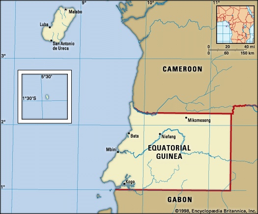
Equatorial Guinea, flag ofcountry located on the west coast of Africa. It consists of Río Muni (also called Mbini), on the continent, and five islands: Bioko (formerly Fernando Po), Corisco, Great Elobey (Elobey Grande), Little Elobey (Elobey Chico), and Annobón. The capital of the republic is Malabo on Bioko. Bata is the administrative capital of the mainland.
Continental Equatorial Guinea is a roughly rectangular territory bounded by Cameroon to the north and Gabon to the east and south. Near the continental coast are the small islands of Corisco and Great and Little Elobey. Bioko, by far the largest of the islands, lies off the coast of Cameroon. Annobón, a volcanic island, lies south of the equator almost 400 miles (640 kilometres) to the southwest of Bioko.
Equatorial Guinea is beset by regional differences, geographic isolation, a fragile economy, and a lack of trained personnel, in part a legacy from the colonial era. Formerly a colony of Spain with the name Spanish Guinea, the country achieved its independence on Oct. 12, 1968.
The land
Relief, drainage, and soils
Half of the continental enclave is covered with forests. A coastal plain about 12 miles wide abuts on the coastal hills, which lead to inland plateaus (called mesetas in Spanish) that rise toward the frontier with Gabon. There are several ranges of hills. The central range divides the Benito River basin to the north from the southern basin of the Utamboni River. The Niefang-Mikomeseng range north of the Benito River is somewhat lower. All these ranges form segments of the Cristal Mountains in Gabon. The region is divided by the Benito River (known as the Woleu River in Gabon), which runs generally from east to west and is nonnavigable except for the first 12 miles inland. To the north the Campo River (called the Ntem in French-speaking Africa) marks part of the frontier with Cameroon.
In the south, the Muni is not itself a river but the estuary of various rivers of Gabon and southern Equatorial Guinea. To the east the de facto border with Gabon follows the meandering course of the Kié (Kyé) River rather than the legal frontier, which runs along a line 11° 20′ east of the Greenwich meridian. Except for limited hydroelectric power generation and the use of waterpower at some lumbering sites, the rivers of the mainland enclave are not exploited. The coast consists of a long stretch of beach with low cliffs toward Kogo to the south. Equatorial Guinea has no natural harbour, and Mbini and Kogo are no more than rudimentary ports of call for the ships that infrequently visit. Bata, on the other hand, has been enlarged artificially to become one of the country's main ports.
The coastal plain is overlaid by sedimentary deposits. The hinterland is composed primarily of ancient metamorphic rocks that have undergone a lengthy process of leaching and erosion, so that the resulting soils are relatively infertile. Exploration in the waters off the mainland has revealed some reserves of petroleum and natural gas, and there are prospects for their development. Gold, manganese, iron ore, and uranium are thought to exist in commercially exploitable quantities inland.
The main island, Bioko, is about 45 miles long and 22 miles wide. Its extinct volcanic cones, crater lakes, and rich lava soils form a contrast with the landscape of the mainland. In the north Mount Santa Isabel soars to a height of 9,878 feet (3,011 metres); this extinct volcano is the site of a television transmitter. In the centre of the island, Moca Peak and the Moca Heights present an alpine type of landscape. The southern part of the island, remote and scarcely developed, consists of the Gran Caldera range, which is rugged and indented by torrents and crater lakes.
Despite its tortuous relief, Bioko can be productive agriculturally. Torrents are exploited for hydroelectric power; the Musola River provides electricity for much of Malabo. The coast is largely inhospitable, consisting for the most part of a cliff about 60 feet high, broken occasionally by small inlets and beaches. The southern coast is very steep and dangerous to shipping; San Antonio de Ureca, located along this stretch, is the most isolated settlement on the island. Malabo has a relatively good harbour, built on the partially sunken rim of a volcano.
Annobón is an isolated fragment of the republic, about 93 miles southwest of the island of São Tomé in São Tomé and Príncipe and about 400 miles southwest of Bioko. Like the latter, it is a volcanic island but is less high; it consists of a conglomeration of cones of which Mount Santa Mina (about 2,460 feet) is the highest. Not quite four miles long by two miles wide, it is a rugged island with only one settlement of note. The inhabitants are mostly fishermen who speak a Portuguese patois.
Climate
The climate of both the continental region and the islands is typically equatorial, with high temperatures, heavy rainfall, and much cloud cover most of the year. Local variations are due to differences in altitude and proximity to the sea. The wet seasons in the continental region are from February to June and from September to December. Rainfall is higher on the coast than inland. In Bata the rainiest months are September, October, and November, with rainfall averaging more than 94 inches (2,388 millimetres) a year. At Calatrava, farther south on the coast, it sometimes reaches 180 inches. Inland, however, rainfall diminishes; Mikomeseng, for example, receives only about 58 inches. The average annual temperature is about 79° F (26° C) and is fairly constant throughout the year. The temperature maxima are somewhat lower than in Bioko. The relative humidity, however, is higher than in Bioko.
Bioko has a rather debilitating climate. The so-called dry season lasts from November to March, and the rest of the year is rainy. The average annual temperature of about 77° F (25° C) varies little throughout the year. Afternoon temperatures reach the high 80s F (low 30s C) and drop to only about 70° F (21° C) at night. Most of the time the sky is cloudy and overcast. Extreme rainfall occurs in the south, with rain brought by monsoon winds amounting to about 450 inches a year around San Antonio de Ureca.
Plant and animal life
Continental Equatorial Guinea is covered by dense tropical rain forest that is exploited by the lumbering industry. More than 140 species of wood are found, of which the most important commercially are okume (Aucoumea klaineana), African walnut, and various mahoganies. Intensive exploitation close to the coast led the Spanish timber companies to venture deeper into the interior. Reforestation is minimal, and a secondary forest growth has replaced the virgin rain forest. African subsistence farmers clear the land by burning off the vegetation cover, after which they grow cassava, beans, yams, roots, and some cash crops such as coffee and cocoa, to the extent that the heavily leached soils allow. Mangroves fringe long stretches of the coast as well as riverbanks.
Bioko has a greater variety of tropical vegetation, including mangroves, and—at higher altitudes—vegetable gardens and pastureland.
The continental region has a rich animal life that includes gorillas, chimpanzees, various rare species of monkeys, leopards, buffalo, antelope, elephants, hippopotamuses, crocodiles, and various species of snakes, including pythons. Insects, including the tsetse fly and the malaria-bearing Anopheles mosquito, as well as hosts of ants, beetles, spiders, and termites, abound. Bioko has no big game but has various monkeys, dwarf antelopes, and rodents, as well as the mosquito and other insects.
Settlement patterns
The mainland is sparsely settled by coffee and cocoa farmers who practice traditional methods of agriculture. During the colonial period, Roman Catholic missions did much to encourage the population to construct “corridor” villages by the sides of roads; in most villages the church and the school figure prominently. The region was never a settler colony, and the few European plantations—mostly Spanish or German—that survived the colonial era have been abandoned. After independence an exodus of Spanish technicians occurred, so that the mainland has largely reverted to a subsistence economy. The modern sector of the economy is represented by lumbering and coffee and oil palm cultivation.
Bioko, by contrast, is a plantation island; it retained for several years a larger number of plantation owners and managers and consequently withstood longer than the continental region the effect of independence upon its economy. Before independence there were about 1,900 plantations (known as fincas), which ranged in size from 0.4 acre (one hectare) to more than 4,900 acres. The Bubi people, the indigenous population, live for the most part in mission villages in the northern part of the island on the lower slopes of Mount Santa Isabel, as well as in their traditional homeland, the Moca Heights. Unused to plantation labour, they gain their living mostly as small farmers and minor civil servants. The workers on the fincas were for many years migrant labourers from Nigeria, who served under contract. During the 1960s the Nigerian workers often brought their families, settling in numbers believed to have reached 50,000 to 80,000 by the end of the decade. Political and economic conditions after independence gradually reduced these numbers, despite an agreement with Nigeria in 1972 for the recruitment of new labourers. Reports of virtual slave-labour conditions on plantations and of repressive killings by authorities in the mid-1970s turned this gradual exodus into a flood, further impoverishing Equatorial Guinea's economy.
Many of the formerly European-owned plantations were extensive; in 1962 more than 300 plantations occupied over 148,000 acres, leaving about 2,800 acres in the possession of 1,600 African farmers grouped in cooperatives. Some of the larger plantations, employing hundreds of Nigerian labourers and occupying the most fertile land, were local economic powers whose political influence, if subdued, was nevertheless felt by the local Bubi population.
Malabo, the national capital, is a small city standing behind its crater harbour. Created by the British in the 19th century, it was remodeled and developed by the Spanish. A rambling tropical city, it has a distinctly Spanish atmosphere—especially in the European district near the cathedral, the mission, and the government house. Farther inland, the African districts were inhabited mostly by Nigerian and other workers who first chose not to return to the mainland. Another town of some importance is Luba, on the southwest coast, linked with the capital by a good paved road that runs through a series of Bubi settlements. Basilé, on the slopes of Mount Santa Isabel, provides a cool refuge for heat-weary residents of the capital.
The continental region was settled much later by the Spanish, so that Bata, the main settlement, lacks the amenities of Malabo. Fang migrants from the interior have built new suburbs around this sprawling port city.
The people
Ethnic composition
The majority of the population (Equatorial Guinea) is African, but its composition is complex for a political unit so small in size. The Fang people, who fought their way to the sea in the 19th and early 20th centuries by subjugating the weaker ethnic groups in their path, form about 80 or 90 percent of the population of the mainland region. North of the Mbini River are the Ntumu Fang, and to the south of it are the Okak Fang. Holding political power on the mainland, the Fang tend to migrate to Bioko, where their leaders hold most of the levers of political control. Coastal groups, such as the Kombe, Mabea, Lengi, Benga, and others, have been in contact with European traders much longer, and a limited amount of intermarriage between European and African ethnic groups has taken place, especially on the island of Corisco. Spanish ethnographers refer to these coastal tribes as playeros (literally, “those who live on the beach”). Both the Fang majority and the playero minority are Bantu (Bantu peoples).
The original inhabitants of Bioko are the Bubi, descendants of Bantu migrants from the mainland. Contacts with Europeans decimated them, and only a few thousand remained early in the 20th century. They became the most pro-Spanish element of the African population, viewing the end of Spanish rule as a signal for the invasion of their island by the Fang. Certainly, numbers of mainlanders, most of them Fang, have flocked to the island since the mid-1960s, seeking to join the civil or military forces or to receive political patronage. In addition to these two groups, there are Fernandinos, descendants of former slaves liberated by the British during the 19th century who mingled with other emancipated Africans from Sierra Leone and Cuba as well as with immigrants from other western African countries. Formerly constituting an influential bourgeoisie, they lost much of their status both when the Spanish acquired the island and after independence. The inhabitants of Annobón are descended from slaves imported by the Portuguese when the island was a dependency of São Tomé; some of them now live on Bioko.
By about 1970, these different strata together constituted a minority on the island, the majority being formed by the Nigerian contract labourers, who lived in compact colonies in Malabo or on the plantations. The repatriation by Nigeria, however, of at least 45,000 workers beginning in 1975, following reports of repressive conditions in Equatorial Guinea, led to extensive realignment of the demographic, social, and labour structures of the island and, indeed, of the country. Additional communities on the island are formed by crioulos (of mixed Portuguese and African origin) from the islands of São Tomé and Príncipe; there are also some Cameroonians.
Linguistic composition
While each ethnic group speaks its own language, other linguistic influences are at work. The first is Spanish (Spanish language), the official language of the republic, which is taught in schools and used by the press and is the only means of communication common to both Bioko and the mainland. The second influence is pidgin English, which is used extensively in petty commerce and forms the lingua franca on Bioko. Third, as a result of closer economic association with Francophone countries begun in 1983, French (French language) became a compulsory subject in schools in 1988 and, along with Spanish, an official language in 1997. A Portuguese patois is also spoken in both Bioko and Annobón.
Religion
While the vast majority of Equatorial Guineans are nominally Roman Catholic, the Bubi and mainlanders often retain traditional forms of worship, which are emphasized in times of crisis. The Mbwiti cult on the mainland, banned by the Spanish authorities, still has adherents. Most churches were closed by presidential order in 1975, and the Roman Catholic church was banned in 1978. These orders were rescinded after the coup in 1979, but many denominations, notably Jehovah's Witnesses, were proscribed once again in 1986.
Demographic trends
The population was reduced by about one-third through the departure of some 110,000 citizens after 1968 and the repatriation of Nigerian workers by 1976. The rates of population increase, density, and life expectancy are lower than those of most other African countries.
The economy
Resources
Equatorial Guinea's economy depended traditionally on three commodities—cocoa, coffee, and timber—but, with the discovery and exploitation of significant reserves of petroleum and natural gas from the 1980s, the country's economic profile changed virtually overnight. Petroleum now accounts for nearly four-fifths of Equatorial Guinea's exports and contributes nearly two-thirds of its gross domestic product (GDP).
Agriculture and forestry
Before independence, the Spanish subsidized cocoa and coffee exports to Spain. The high-quality cocoa was the mainstay of the economy of Bioko, which possessed the right soil and climate for its intensive cultivation. Most of Equatorial Guinea's cocoa is still produced on the island. As with other commodities, production declined under the regime of Francisco Macías Nguema (1968–79) because Nigerian and local workers left the cocoa plantations and maintenance, output, and quality declined. Cocoa exports dropped to one-tenth of their former level, and exports of coffee almost ceased from island and mainland plantations, the small production of robusta coffee by Fang farmers in Río Muni alone being marketed. The timber companies are entirely European; there were at one time 30 timber concessions in operation on the mainland.
Ed.
Bananas are grown on Bioko, where they are exported from the port of Luba. The output of palm oil from mainland plantations has been adversely affected by the unsettled state of the country.
Industry
There is little industry in Equatorial Guinea. Some cocoa and coffee processing takes place locally on plantations and in African cooperatives.
Finance and trade
Following the economic collapse of the mid-1970s, imports came to exceed exports. The gap was narrowed only by external aid, which began to increase after 1979. Since independence the national budget has been balanced first by large Spanish subsidies and since 1981 by help from many nations and agencies.
A major economic reorientation took place in December 1983 when Equatorial Guinea joined the Customs and Economic Union of Central Africa (UDEAC). The country entered the Franc Zone in January 1985, acquiring a freely convertible currency and more French aid. French economic influence is growing.
Transportation
The road network on the mainland was adequate for the light traffic it was required to carry before independence, but it deteriorated in the 1970s. Bata is linked with Mbini by a tarred road. There is a cross-country road from Bata, branching at Niefang and Ncue, to Ebebiyin, Mongomo, and Nsoc near the Cameroon frontier. There are no railways. On Bioko the road system is of a higher standard, with a semicircular tarred road linking Malabo and Luba to the eastern Bubi villages.
The main port is Malabo, which is connected to Spanish and other European ports by regular steamer services. The harbour at Bata was enlarged and modernized in the 1980s and is expected to accommodate a growing share of the country's commerce. European Economic Community aid provided a small coaster in the mid-1980s to ply between Equatorial Guinean ports, Gabon, Cameroon, and São Tomé and Príncipe. There is an international airport at Malabo. In 1982 an international airline, Aerolíneas Guinea Ecuatorial, was formed, and construction began on a new international airport at Bata in 1983.
Administration and social conditions
Government
Under the constitution of 1991, Equatorial Guinea is a republic. Executive power is vested in the president, who is elected by direct universal suffrage for a seven-year term. The president appoints the prime minister and the Council of Ministers. The unicameral House of Representatives constitutes the legislative branch of government, members of which are directly elected to five-year terms. The Supreme Tribunal in Malabo is the highest judicial authority; there are also territorial high courts and courts of the first instance in Malabo and Bata.
For administrative purposes, the country is divided into two régiones (regions), which are subdivided into seven provincias (provinces); the provinces are further divided into districts and municipalities.
The ruling party in Equatorial Guinea is the Democratic Party of Equatorial Guinea (Partido Democrático Guinea Ecuatorial; PDGE), formed in 1987. It was the only political party until 1991, when a new constitution allowing opposition parties was adopted. Since then, several other parties have formed, of which the Convergence for Social Democracy (Convergencia para la Democracia Social; CPDS) and the Popular Union (Unión Popular; UP) are the most prominent. Opposition parties do not wield much influence in the government, however, as the PDGE typically has a decisive majority in the House of Representatives and retains the presidency.
Education
Education is compulsory and free for all children between ages 6 and 11, but only about three-fourths of children attend school. Facilities for higher education are provided through Spanish assistance at Bata and Malabo. Efforts have been made to improve educational opportunities, and illiteracy has declined over the years; about four-fifths of the population is literate.
Cultural life
Despite a veneer of Spanish culture and of Roman Catholic religion that is thicker in Bioko than on the mainland, Equatorial Guineans live largely according to ancient customs, which have undergone a revival since independence. Among the Fang of the mainland, witchcraft, traditional music (in which the Fang harp, the xylophone, the great drums, and the wooden trumpet are used), and storytelling survive. Spanish aid is much oriented to educational and health services. Among the Bubi farmers of Bioko, some ancient customs are still followed.
History
The island of Bioko (formerly Fernando Po) was sighted by Fernão do Pó, probably in 1472. At first it was called Formosa (“Beautiful”). Annobón was probably sighted by Ruy de Sequeira on a New Year's Day (hence the name, which means “good year”) between 1472 and 1475, most likely that of 1474. By the Treaty of Tordesillas (Tordesillas, Treaty of) (June 7, 1494), the Portuguese had exclusive trade rights in Africa, and it was not until 1778 that they agreed to cede to Spain the islands of Annobón and Fernando Po as well as rights on the mainland coast between the Ogooué and Niger rivers. These cessions were designed to give Spain its own source of slaves in Africa for transport to Spanish America, where, in exchange, the Spanish confirmed the rights of the Portuguese west of the 50° W meridian in what is now Brazil. The Spanish were soon decimated by yellow fever on Fernando Po, and they withdrew in 1781. No occupation was made on the mainland.
British (British Empire) administration
After the British abolition of the slave trade in 1807, bases were required by the Royal Navy for the effective suppression of the trade. Fernando Po was unoccupied and lay in a strategic situation from which the Niger mouths and the Slave Coast could be watched for slavers. In 1827 the Spanish leased bases for this purpose to the British at Port Clarence (later Santa Isabel, now Malabo), a fine deepwater harbour on the north coast, and in San Carlos Bay on the west coast.
In the absence of the Spanish, the British also became responsible for administering the island. Thereafter, the British landed many freed slaves, in default of knowing their origin or of being able to repatriate them. Freed slaves also came to the island from Sierra Leone and Jamaica, and in the 20th century the descendants of these several groups continued to speak a form of English. Because of the existence of these freed slaves and the absence of any Spanish administration in the area, the United Kingdom made several unsuccessful offers to Spain for the purchase of Fernando Po—e.g., from 1839 to 1841. In 1843 the Royal Navy concentrated its antislavery patrol at Freetown in Sierra Leone, and its buildings on Fernando Po were sold to a Baptist mission.
Spanish Guinea
In 1844 the Spanish made a second effort at effective occupation of Fernando Po, and their first exploration of the mainland was carried out in the two decades ending in 1877. Meanwhile, the Spanish had expelled the British Baptists from Fernando Po in 1858, and in 1879 they began to use it as a penal settlement for Cubans. Following the Spanish-American War (1898), Spanish Guinea remained as Spain's last significant tropical colony. Profiting from the weakness of Spain, France was able to confine mainland Spanish Guinea to its present limited extent. Economic development started only at that time and was concentrated on the richer and healthier Fernando Po. The mainland received significant attention from Spain only after the Spanish Civil War (1936–39).
In 1959 the status of Spanish Guinea was changed, and the region was reorganized into two provinces of overseas Spain, each of which was placed under a civil governor. The citizens, including the Africans, were granted the same rights as those enjoyed by the citizens of Spain. In 1963 a measure of economic and administrative autonomy for the two provinces (which were henceforth known as Equatorial Guinea) was agreed on by plebiscite.
Independence
The movement toward independence began to take shape at the end of 1967. Early the following year the Spanish government suspended autonomous political control and, with the subsequent approval of the Organization of African Unity (OAU), proposed that a national referendum be held to approve the new constitution. The constitution was overwhelmingly approved on August 11 and was followed by parliamentary elections in September and by the proclamation of independence on October 12, 1968.
The first president was Francisco Macías Nguema. After his election in 1971, he assumed wide powers and pushed through a constitution that named him president for life in July 1972. He assumed absolute personal powers in 1973 when the island of Fernando Po was renamed in his honour. He controlled the radio and press, and foreign travel was stopped. In 1975–77 there were many arrests and summary executions, which brought protests from world leaders and Amnesty International. The Nigerian government repatriated its nationals in 1976.
Macías was overthrown in 1979 by his nephew, Lieutenant Colonel Teodoro Obiang Nguema Mbasogo, who led a Supreme Military Council to which he added some civilians in 1981. A less authoritarian constitution was instituted in 1982, followed by the election of 41 unopposed candidates to the House of Representatives in 1983. Although another new constitution in 1991 provided for a multiparty state—leading to the first multiparty elections, held in 1993—there was no indication that Obiang would willingly give up power, and in the 1990s his regime was the subject of much international criticism for its oppressive nature.
In the years leading to the 21st century and beyond, political strife and corruption continued to plague the country and limit economic growth. The president and the members of his party repeatedly won reelection by lopsided margins in ballots that were fraught with charges of fraud. Further, accusations abounded that a clique surrounding the president systematically had pocketed the bulk of the country's considerable oil revenue. As it had done since the 1980s, Obiang's regime continued to claim that it was the subject of several attempted coups, but most of the allegations could not be confirmed. A notable exception was a plot involving foreign mercenaries that was uncovered in 2004.
Additional Reading
Max Liniger-Goumaz, Small Is Not Always Beautiful (1988; originally published in French, 1986), and La Guinée Équatoriale (1979), and Historical Dictionary of Equatorial Guinea, 2nd ed. (1988), are authoritative. René Pélissier, Études hispano-guinéennes (1969), is the only detailed study of the preindependence era. See also Suzanne Cronjé, Equatorial Guinea, the Forgotten Dictatorship (1976); Akinjide Osuntokun, Equatorial Guinea–Nigerian Relations (1978); and Alejandro Artucio, The Trial of Macías in Equatorial Guinea (1979). Further bibliographic information is found in Max Liniger-Goumaz, Guinea Ecuatorial (1974), and periodic supplements.
- complaint
- complement
- complementarity principle
- Complete Peerage, The
- complex
- complexity
- complex number
- Complutensian Polyglot Bible
- Complutensian University of Madrid
- Component Stocks of Dow Jones Industrial Index
- Composita
- composite material
- Composite order
- composition
- Compositional data for selected solar system objects
- composition of atmosphere mars
- Composition of the plagioclase minerals
- compound-nucleus model
- compound pier
- comprador
- comprehensive school
- compression
- compression ratio
- compressive strength test
- compressor