tsunami
water wave
also called seismic sea wave or tidal wave
 catastrophic ocean wave, usually caused by a submarine earthquake, by an underwater or coastal landslide, or by the eruption of a volcano. The term tsunami is Japanese for “harbour wave.” The term tidal wave is frequently used for such a wave, but it is a misnomer, for the wave has no connection with the tides.
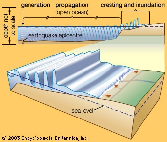 After an earthquake or other generating impulse occurs, a train of simple, progressive oscillatory waves is propagated great distances over the ocean surface in ever-widening circles, much like the waves produced by a pebble falling into a shallow pool. In deep water a tsunami can travel as fast as 800 km (500 miles) per hour. The wavelengths are enormous, about 100 to 200 km (60 to 120 miles), but the wave amplitudes (heights) are very small, only about 30 to 60 cm (1 to 2 feet). The waves' periods (the lengths of time for successive crests or troughs to pass a single point) are very long, varying from five minutes to more than an hour. These long periods, coupled with the extremely low steepness of the waves, enables them to be completely obscured in deep water by normal wind waves and swell. A ship on the high seas experiences the passage of a tsunami as an insignificant rise and fall of only half a metre, lasting from five minutes to an hour or more.
As the waves approach the coast of a continent, however, friction with the rising sea bottom reduces the velocity of the waves. As the velocity lessens, the wavelengths become shortened and the wave amplitudes increase. Coastal waters may rise as high as 30 metres above normal sea level in 10 to 15 minutes. By a poorly understood process, the continental shelf waters begin to oscillate after the rise in sea level. Between three and five major oscillations generate most of the damage, frequently appearing as powerful “run-ups” of rushing water that uproot trees, pull buildings off their foundations, carry boats far inshore, and wash away entire beaches, peninsulas, and other low-lying coastal formations. Frequently the succeeding outflow of water is just as destructive as the run-up or even more so. In any case, oscillations may continue for several days until the ocean surface reaches equilibrium.
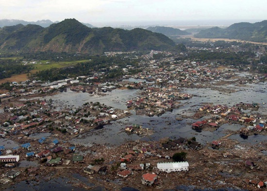
Much like any other water waves, tsunamis are reflected and refracted by the topography of the seafloor near shore and by the configuration of a coastline. As a result, their effects vary widely from place to place. Occasionally, the first arrival of a tsunami at a coast may be the trough of the wave, in which case the water recedes and exposes the shallow seafloor. Such an occurrence took place in the bay of Lisbon (Lisbon earthquake of 1755), Portugal, on November 1, 1755, after a large earthquake; many curious people were attracted to the bay floor, and a large number of them were drowned by the wave crest that followed the trough only minutes later. The most destructive tsunami (Indian Ocean tsunami) ever recorded took place on December 26, 2004, after an earthquake of magnitude 9.0 displaced the ocean floor off the Indonesian island of Sumatra. Two hours later, waves as high as 9 metres (30 feet) struck the eastern coasts of India and Sri Lanka, some 1,200 km (750 miles) away. Within seven hours of the quake, waves washed ashore on the Horn of Africa, more than 3,000 km (1,800 miles) away on the other side of the Indian Ocean. More than 200,000 people were killed, most of them on Sumatra but thousands of others in Thailand, India, and Sri Lanka and smaller numbers in Malaysia, Myanmar, Bangladesh, Maldives, Somalia, and other locations. Previous to this event, the most destructive tsunami in terms of human lives was caused by the spectacular explosive eruption of the Krakatoa (Krakatau) volcano on August 26 and 27, 1883. This series of blasts, which submerged the island of Rakata between Sumatra and Java, created waves as high as 35 metres (115 feet) in many East Indies localities, killing more than 36,000 people. The largest earthquake ever recorded (magnitude 9.5) took place in 1960 off the coast of Chile; it caused a tsunami that killed approximately 2,000 people in Chile, 61 people 15 hours later in Hawaii, and 122 people 22 hours later in Japan.
The hazards presented by tsunamis have brought many countries in the Pacific basin to establish tsunami warning systems. A warning may begin with an alert by a geological society that an earthquake large enough to disturb the ocean's surface (for instance, magnitude 7.0 or higher) has occurred. Meteorological agencies may then report unusual changes in sea level, and then the warning centre may combine this information with data on the depth and features of the ocean floor in order to estimate the path, magnitude, and arrival time of the tsunami. Depending on the distance from the seismic disturbance, government authorities may have several hours' notice to order the evacuation of coastal areas. The Pacific Tsunami Warning Center, located near Honolulu, Hawaii, was established in 1949, three years after a tsunami generated by a submarine earthquake near the Aleutian Islands struck the island of Hawaii around Hilo, killing more than 170 people. It serves as one of two regional warning centres for the United States—the other is located in Palmer, Alaska—and since 1965 it has also served as the warning centre for 26 countries organized by UNESCO's Intergovernmental Oceanographic Commission into the International Coordination Group for the Tsunami Warning System in the Pacific. Following the disaster of December 2004, UNESCO set a goal of establishing similar systems for the Indian Ocean and eventually the entire globe.
- John Major
- John Malalas
- John Malcolm Brinnin
- John Manners Granby, Marquess of
- John Manners, Marquess of Granby
- John Marbeck
- John Marin
- John Marsh
- John Marshall
- John Marshall Harlan
- John Marston
- John Martyn
- John Masefield
- John Maurice Clark
- John Maurice Of Nassau
- John Mauropous
- John Maxwell, 4th Baron Herries
- John Maxwell Herries, 4th Baron
- John Mayall
- John Mayer
- John Maynard Keynes
- John Mayow
- John M. Bozeman
- John McCain
- John McCloskey