Grand Canyon
canyon, Arizona, United States
Introduction
 immense canyon cut by the Colorado River into the high-plateau region of northwestern Arizona, U.S., noted for its fantastic shapes and coloration.
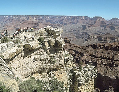
The Grand Canyon lies in the southwestern portion of the Colorado Plateau, which is a large area of the southwestern United States consisting essentially of horizontal, layered rocks and lava flows. The broad, intricately sculptured chasm of the canyon contains between its outer walls a multitude of imposing peaks, buttes, gorges, and ravines. It ranges in width from about 0.1 to 18 miles (0.2 to 29 km) and extends in a winding course from the mouth of the Paria River, near Lees Ferry and the northern boundary of Arizona, to Grand Wash Cliffs, near the Nevada line, a distance of about 277 miles (446 km). Its greatest depths lie more than a mile (some 6,000 feet 【1,800 metres】) below its rim. The canyon includes many tributary side canyons and surrounding plateaus. The deepest and most impressively beautiful section, 56 miles (90 km) long, is within the central part of Grand Canyon National Park, which encompasses the river's length from Lake Powell (formed by Glen Canyon Dam in 1963) to Lake Mead (Mead, Lake) (formed by Hoover Dam in 1936). In its general colour, the canyon is red, but each stratum or group of strata has a distinctive hue—buff and gray, delicate green and pink, and, in its depths, brown, slate-gray, and violet. At approximately 8,200 feet (2,500 metres) above sea level, the North Rim is some 1,200 feet (3,658 metres) higher than the South Rim.
Geologic history
Although its awesome grandeur and beauty are the major attractions of the Grand Canyon, perhaps its most vital and valuable aspect lies in the time scale of Earth history that is revealed in the exposed rocks of the canyon walls. No other place on Earth compares with the Grand Canyon for its extensive and profound record of geologic events. The canyon's record, however, is far from continuous and complete. There are immense time gaps; many millions of years are unaccounted for owing to gaps in the strata that resulted either from vast quantities of materials being removed by erosion or because there was little or no deposition of materials. Thus, rock formations of considerably different ages are separated only by a thin, distinct surface that reveals the vast unconformity in time.
 Briefly summarized, the geologic history of the canyon strata is as follows. The crystallized, twisted, and contorted unstratified rocks of the inner gorge at the bottom of the canyon are Archean granite and schist more than 2.5 billion years old. Overlying these very ancient rocks is a layer of Proterozoic limestones, sandstones, and shales that are more than 540 million years old. On top of these are Paleozoic rock strata composed of more limestones, freshwater shales, and cemented sandstones that form much of the canyon's walls and represent a depositional period stretching over 300 million years. Overlying these rocks in the ordinary geologic record should be a thick sequence of Mesozoic rocks (248 to 65 million years old). Rocks dating from the Mesozoic Era in the Grand Canyon, however, have been entirely eroded away. These rocks are found, nonetheless, in nearby southern Utah, where they form precipitous butte remnants and vermilion, white, and pink cliff terraces. Of relatively recent origin are overlying sheets of black lava and volcanic cones that occur a few miles southeast of the canyon and in the western Grand Canyon proper, some estimated to have been active within the past 1,000 years. (See also Grand Canyon Series.)
The cutting of the mile-deep Grand Canyon by the Colorado River is an event of relatively recent geologic history that began not more than six million years ago, when the river began following its present course. The Colorado River's rapid velocity and large volume and the great amounts of mud, sand, and gravel it carries swiftly downstream account for the incredible cutting capacity of the river. Before Glen Canyon Dam was built, the sediments carried by the Colorado River were measured at an average of 500,000 tons per day. Conditions favourable to vigorous erosion were brought about by the uplift of the region, which steepened the river's path and allowed deep entrenchment. The depth of the Grand Canyon is due to the cutting action of the river, but its great width is explained by rain, wind, temperature, and chemical erosion, helped by the rapid wear of soft rocks, all of which steadily widened it.
The most significant aspect of the environment that is responsible for the canyon is frequently overlooked or not recognized. Were it not for the semiarid climate in the surrounding area, there would be no Grand Canyon. Slope wash from rainfall would have removed the canyon walls, the stair-step topography would long ago have been excavated, the distinctive sculpturing and the multicoloured rock structures could not exist, the Painted Desert would be gone, and the picturesque Monument Valley would have only a few rounded hillocks.
Biological past and present
 Plant and animal fossils are not abundant in the Grand Canyon's sedimentary rocks because of the age of the rocks and are confined mostly to primitive algae and mollusks, corals, trilobites, and other invertebrates.
Animal life in the Grand Canyon area today, however, is varied and abundant. The common animals are the many varieties of squirrels, coyotes, foxes, deer, badgers, bobcats, rabbits, chipmunks, and kangaroo rats. Plant life is also varied. In the bottom of the canyons, where temperatures in the summer can reach a high of 120° F (49° C), are willows and cottonwoods, which require abundant water during the growing season. Drought-resistant plants include the tamarisk, yucca, agave, and numerous species of cactus.
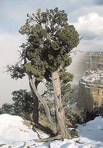
On the canyon rims, north and south, there is a wide assortment of plant life. Typical of the South Rim, which receives about 15 inches (380 mm) of precipitation annually, is a well-developed ponderosa pine forest, with scattered stands of piñon pine and juniper. Bush vegetation consists mainly of scrub oak, mountain mahogany, and large sagebrush. On the North Rim, which receives 26 inches (660 mm) of precipitation annually, are magnificent forest communities of ponderosa pine, white and Douglas fir, blue spruce, and aspen. Under less optimum conditions the plant life reverts to the desert varieties.
History
Many pueblo and cliff-dweller ruins, with accompanying artifacts, indicate prehistoric occupation. The first sighting of the Grand Canyon by a European is credited to the Francisco Coronado (Coronado, Francisco Vázquez de) expedition of 1540, and subsequent discovery to two Spanish priests, Francisco Domínguez and Silvestre Vélez de Escalante (Escalante, Silvestre Vélez de), in 1776. In the early 1800s trappers examined it, and sundry government expeditions exploring and mapping the West began to record information about the canyon. By the 1870s, following the exploration of John Wesley Powell (Powell, John Wesley) and others, extensive reports on the geography, geology, botany, and ethnology of the area were being published.
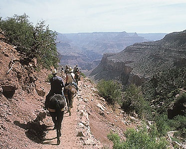
Grand Canyon National Park, now containing 1,904 square miles (4,931 square km), was created in 1919, and its area was greatly enlarged in 1975 by the addition of the former Grand Canyon National Monument and Marble Canyon National Monument and by portions of Glen Canyon National Recreation Area, as well as other adjoining lands. In 1979 the park was designated a World Heritage site. The North and South rims are connected by a 215-mile- (346-km-) long paved road and by a 21-mile- (34-km-) long transcanyon trail. Scenic drives and trails lead to all important features. Mule-pack trips down into the canyon and rides down the river in rafts are intensively sought-after ways of viewing and experiencing the vast beauty of the canyon. Some five million people visit the national park each year. There are five Indian tribes living on nearby reservations.
Additional Reading
Jeremy Schmidt, The Grand Canyon National Park: A Natural History Guide (1993); Ann Zwinger, Downcanyon: A Naturalist Explores the Colorado River Through the Grand Canyon (1995); and Stephen R. Whitney, A Field Guide to the Grand Canyon, 2nd ed. (1996), cover the natural history of the park and present its flora and fauna. Barbara J. Morehouse, A Place Called Grand Canyon (1996), discusses the physical and cultural history of the area from early Native American presence to modern times.John Wesley Powell's 1869 journey through the Grand Canyon is the subject of Edward Dolnick, Down the Great Unknown (2001). Powell's second journey in 1871 and 1872, recorded by the assistant topographer of the expedition, is detailed in Frederick Dellenbaugh, A Canyon Voyage (1908; reissued 1991). An interesting companion to these is Eilean Adams, Hell or High Water: James White's Disputed Passage Through Grand Canyon, 1867 (2001), written by White's granddaughter.Donald L. Baars, Rex C. Buchanan, and John R. Charlton, The Canyon Revisited: A Rephotography of the Grand Canyon, 1923/1991 (1994), combines photos taken by the Birdseye expedition of 1923 with photographs taken in 1991. Other notable photographic records are C.C. Lockwood, Beneath the Rim (1996); and Craig Leland Childs, Grand Canyon: Time Below the Rim (1999), with photographs by Gary Ladd.