Yichang
China
Wade-Giles romanization I-ch'ang
 city, western Hubei (Hupeh) sheng (province), China. It extends along the left bank of the Yangtze River (Chang Jiang), at a point marking the division between the river's middle and lower courses. A number of hills rise directly behind the city, and the small island of Xiba forms a harbour in the river.
About 25 miles (40 km) upstream from Yichang, at Sandouping, is the Three Gorges Dam, which is located at the magnificent Three Gorges section of the Yangtze inside the Xiling Gorge and southern Daba (Daba Mountains) mountain ranges to the west. Prior to the completion of the dam in 2006, the level of the river, which had a violent current, varied enormously—sometimes by as much as 50 feet (15 metres) between high and low water. Despite these drawbacks, Yichang was always an important river port, with much of the traffic from Sichuan province and Chongqing (Chungking) municipality being transshipped onto larger vessels there. The Three Gorges Dam now regulates the Yangtze's downstream flow, thus reducing the fluctuations in the river's level.
Yichang is an ancient city that underwent many changes of name and was constantly disputed during periods when China was politically divided, being the key gateway to the rich province of Sichuan. Until the 17th century it was usually known either as Yiling Zhou or as Xia Zhou. It received the name Yichang only under the Qing dynasty (1644–1911/12). It was opened to foreign trade as a treaty port in 1877. A Western quarter then grew up alongside the ancient walled city, and its trade grew rapidly; many Western commercial firms established branches there.
In 1914 the first section of a railway from Yichang to Chongqing was laid as part of a projected line from Hankou to Chongqing, but the project was abandoned in the political chaos of the day, and the track was torn up in 1915. (Yichang is now connected by a spur to a line that runs from Jiaozuo in Henan province to Zhicheng, about 15 miles 【25 km】 to the southeast on the Yangtze.) In the 1930s, Yichang also became an air-service stop on the route from China's east coast to Sichuan, and roads were built to provide good local communications. After 1938, during the Sino-Japanese War (1937–45), when the Japanese began to drive up the Yangtze from Hankou, the city was badly damaged by repeated bombing and eventually fell to the Japanese army in 1940. Yichang marked the farthest upstream penetration by the Japanese, and, until the end of the war, its commerce virtually came to a standstill. Shipping did not begin to recover until 1950.
Although it is the collecting and distribution centre for the commerce of the surrounding counties, and although it is on a highway running from Hankou into Sichuan, most of its trade still consists of the transshipment of rice, oils, timber, and natural products from Sichuan and the transshipment of manufactured goods from the north and from the coastal provinces destined for Sichuan. Before World War II it had only a few small rice mills and some engineering facilities connected with shipping. Beginning in the 1950s, however, Yichang experienced rapid industrial growth (machinery, shipbuilding, food processing, pharmaceuticals and chemicals, building materials, and aerospace engineering), and it has become the economic centre of southwestern Hubei.
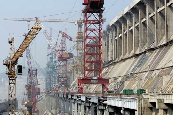 The Gezhouba Dam, a key water-control facility and large hydroelectric power station on the Yangtze, was constructed in the 1970s and '80s in the Yichang area. It remained China's largest hydroelectric facility until the completion of the Three Gorges Dam project. Construction on that massive undertaking began in the 1990s. With the completion of the dam itself, the vast reservoir behind it began to fill. Yichang itself, being downstream, was not affected, but a number of communities in the region under the city's administration were affected, and some 125,000 people were relocated. Power generation, already a chief component of Yichang's economy with the Gezhouba installation, became even more significant as the generating capacity of the Three Gorges scheme came online. Because of Yichang's location at the eastern gateway to the Three Gorges, the city has also become a tourism centre. Pop. (2002 est.) city, 653,040; (2007 est.) urban agglom., 875,000.
- Dessau, Paul
- dessert
- Dessoir, Ludwig
- De Stijl
- Destinn, Emmy
- Destouches, André Cardinal
- Destouches, Philippe Néricault
- Destour
- destroyer
- destruction of the Maine
- Destutt de Tracy, Antoine-Louis-Claude, Comte
- DESY
- Deszö Gyarmati
- detached retina
- Detaille, Édouard
- detection
- detective story
- detergent
- determinant
- determinism
- deterrence
- De Tham
- Detlev, Baron von Liliencron
- Detlev Liliencron, Baron von
- det moderne gennembrud