Nicaragua, Lake
lake, Nicaragua
Spanish Lago De Nicaragua,
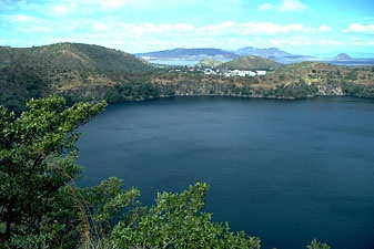 the largest of several freshwater lakes in southwestern Nicaragua and the dominant physical feature of the country; it is also the largest lake in Central America. Its aboriginal name was Cocibolca, meaning “sweet sea”; the Spanish called it Mar Dulce; its present name is said to have been derived from that of Nicarao, an Indian chief whose people lived on the lake shores. Oval in shape, the lake has an area of 3,149 square miles (8,157 square km), is 110 miles (177 km) in length, and has an average width of 36 miles (58 km). About 60 feet (18 m) deep in the centre, its waters reach a depth of 200 feet (60 m) to the southeast of its largest island, Ometepe (Ometepe Island). Its surface is 95 feet (29 m) above sea level.
It is believed that Lake Nicaragua, together with Lake Managua (Managua, Lake) to the northwest, originally formed part of an ocean bay that, as a result of volcanic eruption, became an inland basin containing the two lakes, which are linked by the Tipitapa River. The ocean fish thus trapped adapted themselves as the water gradually turned from saltwater to freshwater. Lake Nicaragua is the only freshwater lake containing oceanic animal life, including sharks, swordfish, and tarpon.
More than 40 rivers drain into the lake, the largest being the Tipitapa River. The San Juan River (Río San Juan) drains out of the lake, following a 112-mile course that runs from the southeastern shore of the lake through a densely forested region to empty into the Caribbean Sea. For part of its course, the San Juan forms the boundary between Nicaragua and Costa Rica. To the southwest, the lake is separated from the Pacific Ocean by a narrow land corridor—the Rivas Isthmus—which is 12 mi wide.
Contrary to popular belief, the lake is tideless, although there is a daily fluctuation in the water level caused by east winds blowing up the San Juan Valley. The water level also falls during the dry season, December to April, and rises during the rainy season, May to October. There are several currents in the lake; the principal one runs from southeast to northeast on the surface, while beneath it a deeper current flows in the opposite direction. Surface water temperature usually remains at 75° F (24° C), and bottom temperature at 60° F (16° C). Due to the chemical composition of the volcanic rocks forming parts of the lake's bed and shores, the lake waters contain high proportions of dissolved magnesium and potassium salts.
There are over 400 islands in the lake, of which 300 are within 5 mi of the city of Granada on the northwest lake shore. Most of the islands are covered with a rich growth of vegetation, which includes tropical fruit trees. Some of the islands are inhabited. Ometepe, which, as mentioned, is the largest island, is 16 mi long and 8 mi wide. It is formed of what originally were two separate volcanoes—Concepción (Concepción Volcano), which is 5,282 ft high and last erupted in 1983, and Madera (Madera Volcano), which is 4,015 ft high. Lava from bygone eruptions forms a bridge between them, called the Tistian Isthmus. (A third volcano associated with the lake is Mombacho, 4,413 ft high, which stands on the western shore.) Ometepe Island is the preeminent site in Nicaragua for pre-Columbian examples of statuary, ceramics, and other archaeological remains, some of which, it is believed, represent vestiges of ancient South American, as well as North American, civilizations. Coffee, cacao, corn (maize), bananas, and fruit are grown on the island as well as a little cotton and tobacco.
The lake is a traditional means of communication between the cities of the west coast of Nicaragua and those in the south and east of the country. Steamships have operated on the lake since the early 1850s. Lake steamers based at Granada visit small lakeside towns, such as San Jorge and La Virgen on the west shore; Cárdenas and San Carlos on the southern shore; San Ubaldo, Puerto Díaz, San Miguelito, and El Morrito on the eastern shore.
In previous centuries, piratical raids from the Caribbean were sometimes made on the lakeside towns, until the building of fortifications in the 17th century on the San Juan River blocked the pirates' ingress. From the time of the ending of Spanish rule in the 1820s, the possibility of constructing a transoceanic canal from the Atlantic to the Pacific, which would run up the San Juan River, cross the lake, and be completed by a channel dug through the Rivas Isthmus, has been mooted. After the discovery of gold in California in 1848, Cornelius Vanderbilt, the New York millionaire, developed the Vanderbilt Road—a route over which gold prospectors from New York were transported up the river and over the lake, completing the final few miles to the Pacific by stage coach in order to take ship for San Francisco in California. The arrangement revived interest—which lasted for many years—in the possibilities of a transoceanic canal. After the completion of the Panama Canal in 1914, interest in the project once more subsided. Since 1916, however, by the provisions of the Bryan-Chamorro Treaty (Bryan–Chamorro Treaty) concluded between Nicaragua and the United States, the United States has had the exclusive right to build such a canal.
- Count Neidhardt von Gneisenau, August
- Count Nesselrode, Karl Vasilyevich
- Count Novosiltsev, Nikolay Nikolayevich
- Count of Nassau Frederick Henry, Prince of Orange
- count of Oldenburg Christopher
- Count Orlov, Aleksey Grigoryevich
- Count Pozzo di Borgo, Charles-André
- Countries Contributing the Largest Numbers of Troops to UN Peacekeeping Missions in 1993, Table
- Country codes of the International Olympic Committee (IOC)
- country dance
- country furniture
- country music
- country rock
- Count Shuvalov, Pyotr Andreyevich
- Count Solaro della Margarita, Clemente
- Count Solomós, Dhionísios
- Count's War
- Count Széchenyi, István
- Count Terauchi Masatake
- Count Tolstoy, Pyotr Andreyevich
- Count Uvarov, Sergey Semyonovich
- count van Egmond, Lamoraal
- count van Horne, Filips van Montmorency
- Count von Berchtold, Leopold
- Count von Bernstorff, Albrecht