Blue Ridge Parkway
route, United States
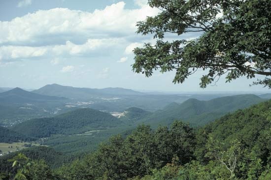 scenic motor route, extending 469 miles (755 km) primarily through the Blue Ridge segment of the Appalachian Mountains in Virginia and North Carolina, U.S. It links Shenandoah National Park (northeast) with Great Smoky Mountains National Park (southwest) and passes through George Washington, Jefferson, and Pisgah national forests. The parkway begins in north-central Virginia near Waynesboro, adjoining the southern end of Skyline Drive (which traverses Shenandoah National Park). It travels generally southwestward, passing Roanoke, Virginia, and Asheville, North Carolina (the parkway's headquarters), before ending near the border between the Cherokee Indian Reservation and Great Smoky Mountains National Park in western North Carolina. The parkway, established in 1936, encompasses a total area of 142 square miles (368 square km) and is administered by the U.S. National Park Service.
Following the crest of the Blue Ridge, with elevations varying from 650 to 6,000 feet (200 to 1,800 metres), the parkway traverses picturesque mountain scenery, and there are facilities for outdoor recreation (camping, hiking, and picnicking) along its route. Forest types vary, the lower elevations being dominated by oaks, middle elevations being covered with northern hardwoods, and higher elevations supporting spruce and fir. Flowering trees and shrubs—such as serviceberry, tulip tree, dogwood, mountain ash, flame azalea, mountain laurel, and catawba rhododendron—add colour to the landscape. In Virginia the Appalachian National Scenic Trail winds around the parkway, and Mabry Mill, a restored early-20th-century gristmill in the south near Woolwine, is a popular tourist stop. North Carolina sites include a minerals museum and the parkway's highest point, Richard Balsam Overlook, which reaches 6,047 feet (1,843 metres). There are four visitor centres in Virginia and seven in North Carolina.
- Menasha
- menat
- Menchik-Stevenson, Vera Francevna
- Menchú, Rigoberta
- Mencius
- Mencken, H.L.
- Mende
- Mendele Moykher Sforim
- mendelevium
- Mendeleyev, Dmitry Ivanovich
- Mendel, Gregor
- Mendelism
- Mendel, Lafayette Benedict
- Mendelsohn, Erich
- Mendelssohn, Fanny
- Mendelssohn, Felix
- Mendelssohn, Moses
- Mendenhall Glacier
- Mendenhall, Thomas Corwin
- Menderes, Adnan
- Menderes River
- Mendes da Rocha, Paulo
- Mendes, Murilo
- Mendes, Sam
- Mendi