Somerset
county, England, United Kingdom
 administrative, geographic, and historic county of southwestern England, bordered on the northwest by the Bristol Channel. The administrative, geographic, and historic counties cover somewhat different areas. The administrative county comprises five districts: Mendip and Sedgemoor in the north, South Somerset and the borough of Taunton Deane in the south, and West Somerset. The geographic county includes the entire administrative county and the unitary authorities of Bath and North East Somerset and North Somerset. Along the borders of the South Somerset district, the administrative and geographic counties include small areas that belong to the historic counties of Dorset and Devon. Apart from these areas, the historic county of Somerset encompasses the entire geographic county, as well as the part of the city of Bristol that lies south of the River Avon.
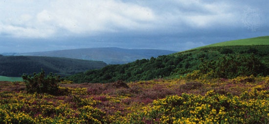 The geographic county is centred on a low-lying basin called Sedgemoor, near the coast. It is bounded on the northeast by the Mendip Hills and on the west by Exmoor and the Quantock Hills. To the north an area of rolling hills, including the southernmost Cotswolds, descends to the valley of the Avon and the lowlands along the Bristol Channel. The Mendips and the Quantock Hills are designated Areas of Outstanding Natural Beauty, and a large part of West Somerset is made up of Exmoor National Park. Long scenic stretches of the county's coastline have been selected for conservation.
 Prehistoric settlement occurred chiefly on the relatively open uplands of the historic county, particularly the Mendip Hills, but a prehistoric lake village has been excavated at Glastonbury. The Romans mined lead, built villas, and founded the town of Bath (Aquae Sulis) at the site of natural hot springs. During the first two centuries of the Saxon conquest, Somerset was a borderland between the Saxons and the Britons, but from the 7th century Somerset formed the westernmost part of the Kingdom of Wessex. During the 11th and 12th centuries the Normans built castles such as those at Dunster and Taunton. During the late Middle Ages Bath flourished as a centre of the woolen trade. Apart from Taunton the county mostly took the Royalist side during the Civil Wars. During the 18th and early 19th centuries Bath enjoyed its heyday as a fashionable resort. With the development of industry and railroads, the town of Taunton expanded, coastal towns such as Weston-super-Mare and scenic areas such as the Exmoor developed as resorts, and the city of Bristol expanded across the River Avon into the historic county.
The geographic county of Somerset is mainly agricultural. Dairy farming and stock raising are important, and there is some market gardening. The county is traditionally associated with cider production, and the village of Cheddar, in the Mendip Hills, has given its name to the cheese.
Limestone and sandstone are quarried in the upland areas of the county, and elsewhere sand and gravel are worked. Peat extraction is important on Sedgemoor. In 1965 a nuclear power station was completed on the coast at Hinkley Point. Manufacturing and engineering are significant in the county's larger towns, such as Taunton and Yeovil. Tourists, pivotal to the economy, are drawn by the architectural treasures of Bath and Wells; by Bristol Channel resorts such as Weston-super-Mare, Minehead, and Burnham; and by a number of National Trust properties and other historic mansions open to the public. The M5 motorway, passing Bridgwater and Taunton, connects Somerset with England's heavily urbanized areas and acts as a major artery in bringing summer visitors to the county. Taunton is the county town (seat). Area administrative county, 1,333 square miles (3,452 square km); geographic county, 1,612 square miles (4,176 square km). Pop. (2001) administrative county, 498,093; geographic county, 855,694.
county, Maine, United States
county, west-central Maine, U.S. It consists of a mountain-and-plateau region bordered by Quebec, Can., to the northwest and drained by the Moose and Kennebec (Kennebec River) rivers. Other waters include Flagstaff, Seboomook, and Brassua lakes. The Appalachian National Scenic Trail traverses the county between Bigelow Preserve on the west and Bald Mountain on the east. Major forest types are spruce, fir, maple, birch, and aspen.
Somerset county was organized in 1809 and named for Somerset, Eng. Skowhegan is the county seat. The principal communities, including Fairfield, Madison, Pittsfield, Norridgewock, and Anson, are located in the southern reaches of the county. The economy relies upon logging, paper milling, and tourism, including hunting and fishing. Area 3,927 square miles (10,171 square km). Pop. (2000) 50,888; (2007 est.) 51,658.
county, Maryland, United States
county, southeastern Maryland, U.S. It consists of a marshy tidewater peninsula bordered by the Wicomico River to the northwest, the Pocomoke River to the southeast, Pocomoke Sound to the south, and Tangier Sound of Chesapeake Bay to the west; it includes Deal, South Marsh, and Smith islands. The Manokin and Big Annemessex river estuaries and Monie Bay carve inlets into the western shore. Six state wildlife management areas, the Martin National Wildlife Refuge, and Janes Island State Park provide recreational opportunities. The county was created in 1666 and named for Lady Mary Somerset, sister-in-law of Cecilius Calvert, 2nd Baron Baltimore. The county seat is Princess Anne. The southern boundary of the county (and state) was not finalized until 1930, when an agreement was reached between Maryland and Virginia.
The economy is based on agriculture (poultry, soybeans, and vegetables), fishing (oysters and crabs), and tourism. Area 327 square miles (848 square km). Pop. (2000) 24,747; (2007 est.) 26,016.
county, New Jersey, United States
county, north-central New Jersey, U.S., bordered to the northeast by the Passaic River and to the east by Green Brook and the Raritan River. Its topography varies from lowlands in the east to a hilly piedmont region in the west. The principal waterways (in addition to the Green, Passaic, and Raritan) are the Millstone, Lamington, and Dead rivers. The primary forest species are oak and hickory. Parklands include Delaware and Raritan Canal Park and Washington Rock State Park.
The Dutch were early settlers in the region—originally inhabited by Delaware Indians—and were followed by a mix of English, Scottish, German, and French. The county was created in 1688 and named for Somerset, Eng. Somerville, the county seat, contains two state historic sites: the Old Dutch Parsonage (built 1751) and the Wallace House, General George Washington (Washington, George)'s winter headquarters (1778–79) during the American Revolution. In 1783 Washington quartered in Rocky Hill at Rockingham—also a state historic site. Other towns include Bound Brook, South Bound Brook, Manville, and Raritan.
Health and business services, pharmaceutical manufacturing, and retail trade are the main industries. Area 305 square miles (789 square km). Pop. (2000) 297,490; (2007 est.) 323,552.
county, Pennsylvania, United States
county, southwestern Pennsylvania, U.S., bordered to the south by Maryland and to the west by Laurel Hill, the Youghiogheny River, and Youghiogheny River Lake. It lies in the Allegheny Mountains and includes Negro and Savage mountains and Mount Davis, the highest point in Pennsylvania (3,213 feet 【979 metres】). The county's waterways include the Casselman River, Quemahoning Reservoir, High Point and Indian lakes, and Lake Somerset, as well as Lake Stonycreek and Laurel Hills, Shade, Stony, and Wills creeks. Kooser and Laurel Hill state parks, parts of Ohiopyle and Laurel Ridge state parks, and several state forests are located within the county.
Somerset county was created in 1795 and named for Somerset, Eng. The principal boroughs are Somerset (the county seat), Windber, Berlin, Central City, Boswell, and Rockwood. The economy depends on manufacturing, services, retail trade, bituminous coal mining, and agriculture (dairy, livestock, and field crops). Area 1,075 square miles (2,784 square km). Pop. (2000) 80,023; (2007 est.) 77,861.
- Izu Peninsula
- Izvestiya
- Izvolsky, Aleksandr, Count
- Izyum
- Iñigo López de Mendoza, marqués de Santillana
- Iñigo López de Mendoza Santillana, marqués de
- Iñárritu, Alejandro González
- Jaan Tönisson
- Jaap Kunst
- Jabalpur
- Jabal Shammar
- Jabavu, Davidson Don Tengo
- J A Bengel
- jabiru
- Jablonec nad Nisou
- Jablonski, Daniel Ernst
- Jabneh
- Jaboatão
- jaboticaba
- Jabotinsky, Vladimir
- Jaca
- jacamar
- jacana
- jacaranda
- Jacareí