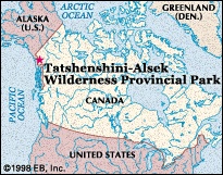
Tatshenshini-Alsek Wilderness Provincial Park
park, Canada-United States

wilderness park, extreme northwestern British Columbia, Canada, sandwiched between Yukon Territory (Yukon) to the north and the Alaskan Panhandle (U.S.) to the west and south. It was created in 1993 largely to prevent the open-pit mining of a large copper deposit at the head of Tats Creek (Windy Craggy), now in the centre of the park. Designated a World Heritage site by UNESCO in 1994, the park has an area of 3,699 square miles (9,580 square km). It borders Kluane National Park and Reserve in the Yukon to the north, the southernmost tip of Wrangell–St. Elias National Park and Preserve (Wrangell–Saint Elias National Park and Preserve) in Alaska to the northwest, and Glacier Bay National Park and Preserve in Alaska to the southeast; the Haines highway forms its eastern boundary.
The St. Elias Mountains (Saint Elias Mountains) and accompanying ice fields and glaciers are located in the western part of the park. To the south Mount Fairweather (Fairweather, Mount) (15,300 feet 【4,663 metres】) rises just beyond the park's border. Lower in elevation, the Alsek Ranges are found in the eastern part of the park; alpine tundra covers portions of the Alsek Ranges. The southward-flowing Alsek River and one of its main tributaries, the Tatshenshini River, cut across the central part of the park, where they have formed wide U-shaped valleys. There are spruce forests at lower elevations, and wildlife includes rare “blue” or “glacier” bears, Dall sheep, grizzly bears, a variety of water fowl, and salmon. River rafting and guided hunting are permitted in the park.
- Vinton Gray Cerf
- vinyl acetate
- vinyl chloride
- vinyl compound
- vinyl fluoride
- vinylidene chloride
- Vinícius de Morais
- viol
- Viola
- viola
- Viola Allen
- Viola, Bill
- Violence Against Women Office
- Violeta Barrios de Chamorro
- Violette Verdy
- violin
- Violle, Jules
- Viollet-le-Duc, Eugène-Emmanuel
- Viotti, Giovanni Battista
- viper
- viperfish
- Viphya Mountains
- Vipsania Agrippina
- Viracocha
- viral hemorrhagic fever