Zacatecas
Mexico
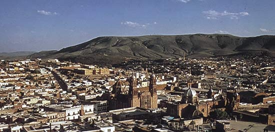 city, capital of Zacatecas estado (state), north-central Mexico. Located in the southern part of the state, it lies in a deep, narrow ravine, about 8,200 feet (2,500 metres) above sea level. The city's name means "place where zacate grass grows."
The historic centre of Zacatecas was designated a UNESCO World Heritage site in 1993. The cathedral, noted for its highly carved portico, was begun in 1612 and completed in the mid-1700s. It contained European paintings and elaborate silverwork and goldwork until the 1850s and '60s, when most of them were confiscated by reformists. The extensive pre-Columbian ruins of La Quemada (Chicomóztoc) are about 30 miles (50 km) south-southwest of the city.
The site of the present-day city had long been an indigenous mining centre when a Spanish town was founded there in 1548 by Juan de Tolosa, Cristóbal de Oñate, Diego de Ibarra, and Baltasar Tremiño. It was designated a city in 1585, two years after silver was discovered in the area by Spaniards. During the colonial era the mines around Zacatecas yielded as much as one-fifth of the world's silver production. Mining is still important, and the city is also a commercial and manufacturing centre for an agricultural hinterland that produces wheat, corn (maize), and livestock. Among its light manufactures are motor vehicle components and clothing. Zacatecas has an airport and is linked by highway and railroad with Ciudad Juárez and Mexico City. Pop. (2000) city, 113,947; urban agglom., 232,965.
state, Mexico
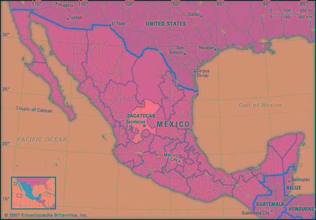 estado (state), north-central Mexico. It is bordered by the states of Coahuila to the north, San Luis Potosí to the east, Jalisco and Aguascalientes to the south, and Nayarit and Durango to the west. Its capital is the city of Zacatecas.
The state's territory lies largely within the arid Mexican Plateau, with the Sierra Madre Occidental traversing the southwestern region and the Sierra Madre Oriental reaching the northeastern corner. The average elevation on the plateau is about 7,700 feet (2,350 metres); the climate is dry and warm in the valleys and temperate in the mountains. The state's major rivers are the Atengo, Jerez, Juchipila, San Andrés, Tlaltenango, and Valparaíso. Precipitation averages about 20 inches (500 mm) per year.
The state's mineral wealth, consisting primarily of silver (silver processing), was discovered soon after the Spanish conquest. From the mid-16th century the mines there were among the largest sources of wealth in the Spanish colonies, comparable only to Upper Peru's Cerro Rico (now in Potosí, Bolivia). Agriculture (cereals, alfalfa, sugarcane, and maguey, from which the alcoholic beverage pulque is made) is also an important occupation, but the low rainfall limits crop yields, and only a small proportion of the state's farmland is irrigated. Cattle are raised, and meat processing is important. Manufactures are limited chiefly to mineral products, sugar refining, beverages (notably rum, pulque, and mescal), and woolen and cotton textiles.
State government is headed by a governor, who is elected to a single six-year term. Members of the unicameral State Legislature are elected to three-year terms. Like other Mexican states, Zacatecas is divided into local governmental units called municipios (municipalities). In the late 20th century Zacatecas became part of Mexico's so-called “hollow core” as many of its residents moved elsewhere, seeking work in the United States, along the U.S.-Mexican border, or in the Federal District. The rail, highway, and air routes traversing the state link Zacatecas city with El Paso (Texas) and Mexico City. Area 28,283 square miles (73,252 square km). Pop. (2000) 1,353,610; (2005) 1,367,692.
- West, Jessamyn
- West, Kanye
- West Lafayette
- Westlake, John
- West Lancashire
- Westland National Park
- West Liberty State College
- West Lindsey
- West Lothian
- West, Mae
- Westmeath
- West Memphis
- West Midlands
- Westminster
- Westminster Abbey
- Westminster Assembly
- Westminster Catechism
- Westminster, City of
- Westminster Confession
- Westminster School
- Westminster, Statute of
- Westminster, Statutes of
- Westmore Family
- Westmoreland
- Westmorland