Khyber Pass
mountain pass, Pakistan-Afghanistan
Khyber also spelled Khaybar, or Khaibar,
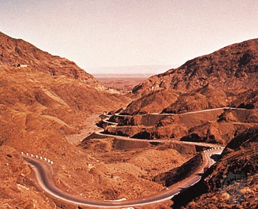 most northerly and important of the passes between Afghanistan and Pakistan. The pass connects Kābul with Peshāwar. The pass has historically been the gateway for invasions of the Indian subcontinent from the northwest. The name Khyber is also applied to the range of arid, broken hills through which the pass runs and which form the last spurs of the Spin Ghar (Safīd Kūh) Range. On either side of the connecting ridge are the sources of two small streams, the beds of which form the Khyber gorge. This narrow gorge forms the Khyber Pass; it winds between cliffs of shale and limestone, 600–1,000 feet (180–300 m) high, and enters the Khyber Hills from the Shadi Bagiār opening, a few miles beyond Jamrūd, Pak., and continues northwestward for about 33 miles (53 km). Just beyond the old Afghan fort of Haft Chāh, it opens onto the barren Lowyah Dakkah plain, which stretches to the Kābul River.
After a steep ascent at its southern entrance, the pass rises gradually to Fort Ali Masjid (3,174 feet), where the Khyber River (Khyber Khwār) leaves the pass to the south. For 5 miles from Ali Masjid the pass becomes a defile not more than 600 feet wide, flanked by imposing and precipitous walls. From Zīntara village on northward, the pass becomes a valley a mile or more wide, with forts, villages, and scattered cultivation plots. About 10 miles west of Ali Masjid lies Landi Kotal fort and cantonment (3,518 feet); this is the highest point in the pass and is also an important market centre with an alternate route back to Peshāwar. There the summit widens out northward for 2 miles. The main pass, however, descends from Landi Kotal through Shinwārī territory to Landi Khāna, where it runs through another gorge and enters Afghanistan territory at Towr Kham (Torkham; 2,300 feet), winding another 10 miles down the valley to Lowyah Dakkah.
The Khyber Pass is threaded by a caravan track and by a good hard-surface road. The railway (opened 1925) through the pass connects Jamrūd with Landi Khāna, near the Afghan frontier; the line, with its 34 tunnels and 94 bridges and culverts, revolutionized transportation in the area. The pass may be skirted by a road fork that enters the hills about 9 miles north of Jamrūd and emerges at Lowyah Dakkah.
Few passes have had such continuing strategic importance or so many historic associations as the Khyber Pass. Through it have passed Persians, Greeks, Mughals, Afghans, and the British, for whom it was the key point in control of the Afghan border. In the 5th century BC Darius I the Great of Persia conquered the country around Kābul and marched through the Khyber Pass to the Indus River. Two centuries later Hephaestion and Perdiccas, generals of Alexander the Great, probably used the pass. Buddhism flourished in and around the Khyber when it was part of Aśoka's kingdom (3rd century BC); Buddhist remains include Kāfir Kot (Citadel of the Kafirs), Shopla stūpa (also called the Khyber Top), and the stūpa near Ali Masjid. The pass was used by Maḥmūd of Ghazna, Bābur, Nāder Shāh, and Aḥmad Shāh Durrānī and his grandson Shāh Zamān in their invasions of India. Ranjit Singh, the Sikh ruler of the Punjab, extended his kingdom as far as Jamrūd in the early 19th century.
The Pashtun Afrīdī people of the Khyber area always resisted foreign control, and numerous punitive expeditions were undertaken against them by the Mughals and the British. The first British advance northward into the Khyber took place in 1839, and during the First Anglo-Afghan War the pass was the scene of many skirmishes with the Afridis. The Treaty of Gandamak, which was signed during the Second Anglo-Afghan War in 1879, left the Khyber tribes under British control. In 1897 the Afridis seized the pass and held it for several months but were defeated in the Tīrāh expedition of 1897. The British became responsible for the safety of the pass, which is now controlled by the Pakistani Khyber Agency.
- Matamoros
- Matane
- Matanzas
- Matapa
- Matapédia Valley
- Matara
- Mataram
- Mataró
- Mataura River
- match
- matchlock
- Matehuala
- Mateo Alemán
- Matera
- Materialism
- materials handling
- materials processing
- materials science
- materials testing
- Mater Matuta
- maternal school
- matha
- mathematical model
- mathematical programming
- mathematicism