Moyle
district, Northern Ireland, United Kingdom
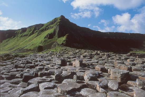 district, Northern Ireland. Formerly within County Antrim, in 1973 Moyle was established as a district along the northern coast of Ireland and includes Rathlin Island, Northern Ireland's only populated island. The district has 42 miles (68 km) of bays, headlands, and sheer, basalt cliffs dissected by wooded glens. The Antrim Mountains extend through eastern Moyle, reaching an elevation of 1,817 feet (554 metres) at Trostan Mountain and descending to high, rolling moors in the west. The area derives its name from “the Straits of Moyle,” an old name for the channel between Northern Ireland and Scotland. A cave on Rathlin Island 3 miles (5 km) north of the mainland is said to have been the hiding place of the Scots-Irish leader Robert the Bruce (Robert I) in 1306. In 1898 Guglielmo Marconi tested his wireless system between a Rathlin Island lighthouse and the town of Ballycastle.
Potatoes, oats, barley, and livestock (mostly sheep) are produced in Moyle, but the district's most important industry is tourism. Other industry is distinctly limited because of the strict planning policies governing the areas of “outstanding natural beauty.” Two of the best known physical features of Northern Ireland, the Giant's Causeway, comprising some 40,000 mostly hexagonal-shaped basalt columns along the coastal cliffs, and five of the nine Glens of Antrim are found in Moyle. Ballycastle, a fishing harbour and popular resort town located on Ballycastle Bay, is the administrative seat and market centre of the district. Limestone is quarried in the west, and Bushmills town, located on the western edge of the district, has an old distillery of Irish whiskey. Area 191 square miles (494 square km). Pop. (2004 est.) 16,424.
- icefish
- ice formation
- ice hockey
- ice in lakes and rivers
- Iceland
- Icelanders' sagas
- Iceland, flag of
- Icelandic language
- Icelandic literature
- Icelandic low
- Iceland moss
- Iceland spar
- Iceman
- Iceni
- ice plant
- ice shelf
- ice skating
- ich
- Ichihara
- Ichikawa
- Ichikawa Family
- Ichikawa Kon
- Ichinomiya
- Ichiro Suzuki
- ichneumon