Caribbean Sea
sea, Atlantic Ocean
Introduction
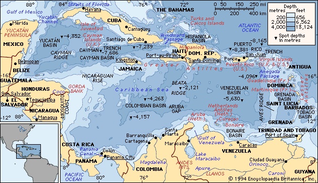
 suboceanic basin of the western Atlantic Ocean, lying between latitudes 9° and 22° N and longitudes 89° and 60° W. It is approximately 1,063,000 square miles (2,753,000 square km) in extent. To the south it is bounded by the coasts of Venezuela, Colombia, and Panama; to the west by Costa Rica, Nicaragua, Honduras, Guatemala, Belize, and the Yucatán Peninsula of Mexico; to the north by the Greater Antilles islands of Cuba, Hispaniola, Jamaica, and Puerto Rico; and to the east by the Lesser Antilles chain, consisting of the island arc that extends from the Virgin Islands in the northeast to Trinidad (Trinidad and Tobago), off the Venezuelan coast, in the southeast. Within the boundaries of the Caribbean itself, Jamaica, to the south of Cuba, is the largest of a number of islands.
 Together with the Gulf of Mexico (Mexico, Gulf of), the Caribbean Sea has been erroneously termed the American Mediterranean, owing to the fact that, like the Mediterranean Sea, it is located between two continental landmasses. In neither hydrology nor climate, however, does the Caribbean resemble the Mediterranean. The preferred oceanographic term for the Caribbean is the Antillean-Caribbean Sea, which, together with the Gulf of Mexico, forms the Central American Sea. The Caribbean's greatest known depth is Cayman Trench (Bartlett Deep) between Cuba and Jamaica, approximately 25,216 feet (7,686 metres) below sea level.
Physical features
Geology
The geologic age of the Caribbean is not known with certainty. As part of the Central American Sea, it is presumed to have been connected with the Mediterranean during Paleozoic (Paleozoic Era) times (i.e., about 540 to 250 million years ago) and then gradually to have separated from it as the Atlantic Ocean was formed. The ancient sediments (marine sediment) overlying the seafloor of the Caribbean, as well as of the Gulf of Mexico, are about a half mile (about one kilometre) in thickness, with the upper strata representing sediments from the Mesozoic (Mesozoic Era) and Cenozoic (Cenozoic Era) eras (i.e., from about 250 million years ago to the present) and the lower strata presumably representing sediments of the Paleozoic and Mesozoic eras. Three phases of sedimentation have been identified. During the first and second phases the basin was free of deformation. The Central American Sea apparently became separated from the Atlantic before the end of the first phase. Near the end of the second phase, gentle warping and faulting occurred, forming the Aves and Beata (Beata Ridge) ridges. Forces producing the Panamanian isthmus (Panama, Isthmus of) and the Antillean arc were vertical, resulting in no ultimate horizontal movement. The sediment beds tend to arch in the middle of the basins and to dip as landmasses are approached. The younger Cenozoic beds (formed during the last 65 million years) are generally horizontal, having been laid down after the deformations occurred. Connections were established with the Pacific Ocean during the Cretaceous Period (from about 144 to 65 million years ago) but were broken when the land bridges that permitted mammals to cross between North and South America were formed in the Miocene (Miocene Epoch) and Pliocene (Pliocene Epoch) epochs (about 25 to 1.8 million years ago).
The existing sediment cover of the seabed consists of red clay in the deep basins and trenches, globigerina ooze (a calcareous marine deposit) on the rises, and pteropod ooze on the ridges and continental slopes (continental slope). Clay minerals appear to have been washed down by the Amazon (Amazon River) and Orinoco (Orinoco River) rivers, as well as by the Magdalena River in Colombia. Coral reefs fringe most of the islands.
Physiography
The Caribbean Sea is divided into five submarine basins, each roughly elliptical in shape, which are separated from one another by submerged ridges and rises. These are the Yucatán, Cayman, Colombian, Venezuelan, and Grenada basins. The northernmost of these, the Yucatán Basin, is separated from the Gulf of Mexico by the Yucatán Channel, which runs between Cuba and the Yucatán Peninsula and has a sill depth (i.e., the depth of the submarine ridge between basins) of about 5,250 feet (1,600 metres). The Cayman Basin, to the south, is partially separated from the Yucatán Basin by Cayman Ridge, an incomplete fingerlike ridge that extends from the southern part of Cuba toward Guatemala, rising above the surface at one point to form the Cayman Islands. The Nicaraguan Rise, a wide triangular ridge with a sill depth of about 4,000 feet (1,200 metres), extends from Honduras and Nicaragua to Hispaniola, bearing the island of Jamaica and separating the Cayman Basin from the Colombian Basin. The Colombian Basin is partly separated from the Venezuelan Basin by the Beata Ridge. The basins are connected by the submerged Aruba Gap at depths greater than 13,000 feet (4,000 metres). The Aves Ridge, incomplete at its southern extremity, separates the Venezuelan Basin from the small Grenada Basin, which is bounded to the east by the Antillean arc of islands.Subsurface water enters the Caribbean Sea across two sills. These sills are located below the Anegada Passage, which runs between the Virgin Islands and the Lesser Antilles, and the Windward Passage, which stretches between Cuba and Hispaniola. The sill depth of Anegada Passage is between 6,400 and 7,700 feet (1,950 and 2,350 metres), whereas that of the Windward Passage is between 5,250 and 5,350 feet (1,600 and 1,630 metres).
Hydrology
North Atlantic deep water enters the Caribbean beneath the Windward Passage and is characterized by its rich oxygen content and by a salinity of slightly less than 35 parts per thousand. From there it divides to fill the Yucatán, Cayman, and Colombian basins at depths near 6,500 feet (2,000 metres). This Caribbean bottom water also enters the Venezuelan Basin, thus introducing high-oxygen water at depths of 5,900 to 9,800 feet (1,800 to 3,000 metres). Subantarctic intermediate water (i.e., water differing in several characteristics from the surface and bottom layers of water that it separates) enters the Caribbean below the Anegada Passage at depths of 1,600 to 3,300 feet (500 to 1,000 metres). Above this water, the subtropical undercurrent and surface water enter. The shallow sill depths of the Antillean arc block the entry of Antarctic bottom water, so that the bottom temperature of the Caribbean Sea is close to 39 °F (4 °C), as compared with the Atlantic bottom temperature of less than 36 °F (2 °C).
Surface currents, bearing both high- and low-salinity water depending on the source, enter the Caribbean mainly through the channels and passages of the southern Antilles. These waters are then forced by the trade winds (trade wind) through the narrow Yucatán Channel into the Gulf of Mexico. The wind-driven surface water accumulates in the Yucatán Basin and the Gulf of Mexico, where it results in a higher average sea level than in the Atlantic, forming a hydrostatic head that is believed to constitute the main driving force of the Gulf Stream. Of the water passing through the Yucatán Channel each second, only about one-fourth represents the deeper Subantarctic intermediate water. The remainder is the surface water that passed over the Antillean arc at depths of less than 2,600 feet (800 metres).
Climate
The climate of the Caribbean generally is tropical, but there are great local variations, depending on mountain elevation, water currents, and the trade winds. Rainfall varies from about 10 inches (25 cm) per year on the island of Bonaire off the coast of Venezuela to some 350 inches (900 cm) annually in parts of Dominica. The northeast trade winds dominate the region with an average velocity of 10 to 20 miles (16 to 32 km) per hour. Tropical storms reaching a hurricane velocity of more than 75 miles (120 km) per hour are seasonally common in the northern Caribbean as well as in the Gulf of Mexico; they are almost nonexistent in the far south. The hurricane season is from June to November, but hurricanes occur most frequently in September. The yearly average is about eight such storms. The Caribbean has fewer hurricanes than either the western Pacific (where these storms are called typhoons (typhoon)) or the Gulf of Mexico. Most hurricanes form in the eastern Atlantic near the Cape Verde Islands (Cape Verde) and follow the path of the trade winds into the Caribbean and the Gulf of Mexico, although the exact path of any hurricane is unpredictable. In 1963 one of the deadliest hurricanes on record, Flora, caused the loss of more than 7,000 lives and extensive property damage in the Caribbean alone. Such storms also have been a major cause of crop failure in the region.
Economic aspects
Resources
 While the vegetation of the Caribbean region is generally tropical, variations in topography, soils, rainfall, humidity, and soil nutrients have made it diverse. The porous limestone terraces of the islands are generally nutrient-poor. Near the seashore, black and red mangroves (mangrove) form dense forests around lagoons and estuaries, and coconut palms typify the sandy vegetation of the littoral. Both the Central American region and the Antillean islands are on the routes of birds migrating to or from North America, so that large seasonal variations occur in the bird populations. Parrots (parrot), bananaquits (bananaquit), and toucans (toucan) are typical resident Caribbean birds, while frigate birds (frigate bird), boobies (booby), and tropic birds (tropic bird) can be seen over the open ocean.
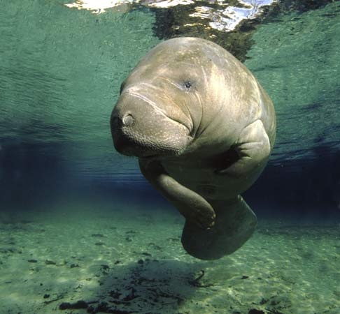 The shallow-water marine fauna and flora of the Caribbean centres around the submerged fringing coral reefs (coral reef), which support diverse assemblages of fishes and other forms of marine life. The marine biota is derived from the Indian and western Pacific oceans via the Panamanic Seaway, which was closed by the rise of the Isthmus of Panama (Panama, Isthmus of) some four million years ago. Coral reef growth throughout the Antillean region is favoured by uniformly warm temperatures, clear water, and little change in salinity. Submerged fields of turtle grass are found in the lagoons (lagoon) on the leeward sides of reefs. Sea turtles (sea turtle) of several species, the manatee, and the manta (devil) ray (manta ray) (Manta birostris) are also characteristic of the region. The spiny lobster is harvested throughout the Caribbean and is sold mainly to restaurants and tourist hotels, while the queen conch and reef fishes are local staples.
 Fishes of commerce are sardines (sardine) from Yucatán and species of tuna. Among common game fish are the bonefishes (bonefish) of the Bahamian reefs, barracuda, dolphin, marlin, and wahoo.
Since the signing of the Law of the Sea Treaty in the early 1980s, no part of the Caribbean remains outside the extended mineral, fishing, and territorial zones of the sea's bordering countries. Explosive human population growth and the overexploitation of marine resources in the region have stimulated international initiatives toward managing and preserving the environment. The Convention for the Protection and Development of the Marine Environment of the Wider Caribbean Region (Cartegena Convention) was adopted officially by about half of the countries of the Caribbean in 1983, but its measures have since been implemented more broadly across the Caribbean community. The Cartegena Convention calls for its signatories to provide—individually and jointly—protection, development, and management of the common waters of the wider Caribbean. Three protocols have been developed and launched under the framework of the convention: cooperation on combating oil spills (1983); establishment of specially protected areas and wildlife (1990); and prevention, reduction, and control of land-based marine pollution (1999).
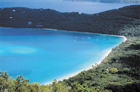
Tourism is an important part of the Caribbean economy, serving primarily the populations of the United States and Canada to the north and Brazil and Argentina to the south. Connections by air and sea between the Caribbean and North America are generally more developed than are interisland connections. With its typically sunny climate and recreational resources, the Caribbean has become one of the world's principal winter vacation resort areas.
Trade (international trade) and transportation
The Caribbean has a complex pattern of trade and communications. The volume of trade per capita is high, but most of this trade is conducted with countries outside the region. Each Caribbean country tends to trade with countries elsewhere that share a common language. Cuba, an exception, trades with a variety of countries, trade with former communist-bloc countries accounting for much of the total. Intra-Caribbean trade is small, owing to limited industrial resources and the monocultural economic pattern. Goods and commodities exchanged within the Caribbean economy are relatively few—rice from Guyana; lumber from Belize; refined petroleum from Trinidad and Curaçao; salt, fertilizer, vegetable oils, and fats from the eastern islands; and a few manufactured products. A lack of capital and limited natural resources generally have discouraged industrial development, although low labour costs and tax incentives have attracted some industry. Markets for most Caribbean products are in the United States and Canada, which import bananas, sugar, coffee, bauxite, rum, and oil. All Atlantic-Pacific shipping via the Panama Canal passes through the Caribbean.
Study and exploration (European exploration)
The first European to enter the Caribbean Sea was Christopher Columbus (Columbus, Christopher), who made landfall in the Bahamas in 1492 convinced that he had discovered a new route to Asia. He continued south to found a key Spanish colony on the island of Hispaniola (now divided politically between Haiti and the Dominican Republic). In his subsequent three voyages, Columbus discovered the major features of the region.
The study of Caribbean natural history began with observations published by early voyagers, notably those of the English buccaneer and explorer William Dampier (Dampier, William) in the late 17th century. The British Challenger Expedition briefly passed through the Caribbean in 1873, followed by more-extensive American expeditions (1877–89) on the Blake. Danish and American expeditions from 1913 to the late 1930s initiated the systematic research of the basin that has continued to the present day, with periodic expeditions mounted by various countries.
The invention of scuba equipment, the development of research submarines, and the establishment of marine research laboratories in a number of countries in the Caribbean region led to a rapid increase in the level of scientific activity in the second half of the 20th century. One of the more-recent areas of research has focused on coral "bleaching" events, including those in 1995 and 1998 off the coast of Belize (on the largest coral barrier reef in the Northern Hemisphere) and in 2005 on the reefs near Puerto Rico and the Virgin Islands. Coral bleaching occurs when the animals that constitute the reef expel associated algae in response to changes in water chemistry (temperature, salinity, acidity, or increases in silt or pollution). The process ultimately kills those animals. One of the leading hypotheses for this phenomenon has been that Caribbean waters have increased in temperature, perhaps as a result of global climate change.
Additional Reading
Caribbean marine science is the focus of a special issue of Oceanus, vol. 30, no. 4 (Winter 1987/88). Fauna and fishery resources are discussed in Susan M. Wells, Coral Reefs of the World, vol. 1, Atlantic and Eastern Pacific (1988); James Cribb, Jacques-Yves Cousteau, and Thomas H. Suchanek, Marine Life of the Caribbean (1984); and J.L. Munro (ed.), Caribbean Coral Reef Fishery Resources, 2nd ed. (1983). The history of the area is chronicled in Germán Arciniegas, Caribbean, Sea of the New World (1946); and W. Adolphe Roberts, The Caribbean (1940, reissued 1969). A review conducted by the British Geological Survey on Caribbean coastal pollution is B.G. Rawlins et al., Review of Currently Available Information on Pollution of Coastal Waters by Sediments and Agro-chemicals in the Caribbean Region with Particular Emphasis on Small Island States (1998). A United Nations-sponsored study of ecological and human responses to climate change in the Caribbean is George A. Maul, Ecosystem and Socioeconomic Response to Future Climatic Conditions in the Marine and Coastal Regions of the Caribbean Sea, Gulf of Mexico, Bahamas, and the Northeast Coast of South America (1993).General references pertaining to international law of the sea with respect to the Caribbean include Law of the Sea Institute, Building New Regimes and Institutions for the Sea (1998); and Elisabeth Mann Borgese, The Law of the Sea and the Caribbean (1991). Analyses of the policies set forth in the Cartegena Convention and the development of the protocol on land-based marine pollution can be found in M.E. Schumacher, P. Hoagland, and A.G. Gaines, “Land-Based Marine Pollution in the Caribbean: Incentives and Prospects for an Effective Regional Protocol,” Marine Policy, 20(2):99–121 (March 1996). Ed.
- Peredvizhniki
- Peregrinatio Etheriae
- peregrine falcon
- Peregrinus of Maricourt, Peter
- Peregrinus Proteus
- Pereira
- Pereira, Irene Rice
- Pereira, Nuno Álvares, Blessed
- Perelman, Grigori
- Perelman, S.J.
- Pereskia
- Peres, Shimon
- perestroika
- Peresvetov, Ivan Semenovich
- Peretz, I.L.
- Peretz Markish
- Pere Ubu
- Pereyaslav Agreement
- Pereyaslav-Khmelnytskyy
- perfect gas
- perfect number
- performance
- performance art
- perfume
- perfume bottle